
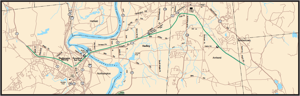
I first saw Audubon Road in the spring of 2012. That May, I took my bike out of the kitchen, where it had leaned against a wall since the previous fall, and began riding daily. That wasn’t unusual: I had biked with some frequency since moving to Northampton in 2006; but my riding had always been rather tame – I mostly used the paved bike paths that criss-cross this area: the Norwottuck Rail Trail, which connects Northampton, Hadley, and Amherst; the Northampton Bikeway, which connects downtown Northampton and Florence; and the Manhan Rail Trail, which connects Northampton and Easthampton. (The map below shows the first two of these.)
In the spring of 2012, for the first time, I began riding the roads around here. That probably doesn’t sound like a big deal; but, for me, it was. The rail trails in this area are lovely – smooth, peaceful, and flat. They are so protected from cars, and other kinds of unpleasantness, that you sometimes feel like you’re traveling in a sealed tunnel designed for your comfort: luscious, green trees line both sides of the path, their canopy shading you from above, as you glide blithely along on your bike, worried only about the occasional pedestrian blocking your way. Of course, what the paths lack in excitement, they make up for in convenience. For me, they have been a great way to get exercise, fresh air, and a chance to think through whatever problems are on my mind.
But the spring of 2012 felt different. The semester was over, and that summer would be my first in nearly a decade without administrative, teaching, or parenting duties. I wanted to stretch my body as well as my mind, to try some new things, and to be, relatively speaking, a different person. And so, on that beautiful May afternoon, I turned off the bike path and headed into the country.
 It was the start of an extraordinary season. I biked more than 1,000 miles that May, June, and July. I rode everywhere: to South Hadley, Belchertown, Sunderland, Montague, Hatfield. I rode up and down steep hills, through rich farmland, in and out of towns. I rode in intense heat and pouring rain, sometimes 30-40 miles at a stretch. Everyday I would get up, write in the mornings, read after lunch, then take off around 3:00 for a bike ride, sometimes with a route in mind, often without.
My first trip that spring was up Audubon Road in northwest Northampton. Using Marion Gorham’s Bicycling the Pioneer Valley (New England Cartographics, 1998) and the Western Massachusetts Road and Bicycle Map (Rubel 1997), I planned to take the Bikeway to Leeds, then ride up River Road and into Williamsburg on Route 9. But when I got to Leeds, I discovered that the bridge on River Road was closed. After consulting my map for an alternative, I decided to head west, up Audubon Road.
That first uphill, after so many years on the rail trails, was a shock. But even further on, when it followed a more gentle incline, Audubon Road involved work. Fortunately, after the road became South Street, the ride was relatively flat. The scenery throughout, mostly rolling farmland, was lovely; but, to be honest, I was too winded to appreciate it. It was nice to finally arrive in Williamsburg – I got a bottle of water at the General Store and walked around town a little. If, on the way back, I mistakenly turned south on Kennedy Road when Audubon curved east, I corrected myself soon enough; and, by late afternoon, I was back on the Bikeway, headed for home.
I did the same trip on June 28, clocking 18 miles on my new cyclometer and recording the trip in my handwritten log. This time I took mental note of the crossroads where Audubon and Kennedy meet, the intersection where I had made a wrong turn in May. It’s a distinctive site, probably the most isolated, lonely spot on the whole route.

A week or so later, on July 5, adapting a ride that Gorham calls “Tour of the Hamptons,” I biked the Manhan Rail Trail southwest to Easthampton and then took off north through the countryside, planning to connect after many miles with the Northampton Bikeway at Leeds. It was an intensely rural route, with visual surprises around every curve. I eventually ended up on Sylvester Road, which after a couple of miles turned into Kennedy Road. Suddenly, without quite expecting it, I was at the crossroads with Audubon: it was like seeing an old friend. This time, I knew exactly which way to turn towards Leeds and the Bikeway home.
I thought no more of this place until the winter of 2013, when I was working on an essay called “The Lost Meadows of Northampton” for The Massachusetts Review. An 1831 map by John Hales plays an important role in that piece, the stippled meadowland by the river having been a clue for me that there was a part of my world that I knew very little about.

Plan of the Town of Northampton by John G. Hales, Boston, 1831. Courtesy of Historic Northampton, Northampton, Massachusetts
While writing that essay, my attention had been drawn to the right side of the map, about halfway down: the floodplain south and east of Northampton’s center. But looking at the map one day, I noticed something in the far upper left-hand corner – something that looked vaguely familiar. It was a crossroads.
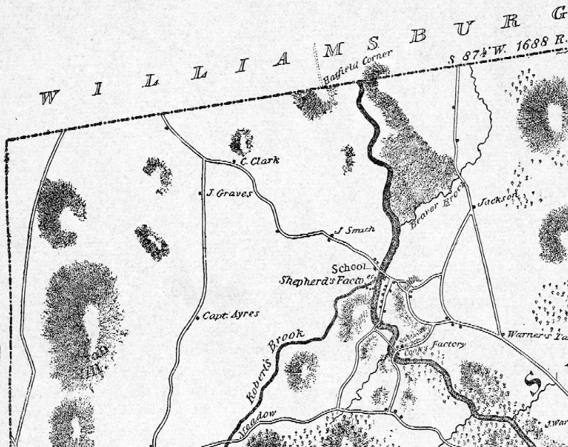
Could it be that this intersection, on an 1831 map, was the same intersection I knew from my summer bike rides up Audubon Road to Williamsburg? Was the lonely crossroads which I had pedaled so breathlessly past in fact a place of deep historical lineage?
These questions were merely abstract until a couple of weeks ago, when the writing of a blog post about Williamsburg brought me back to the Audubon crossroads once again.
Although my mind was now focused elsewhere – namely, on the Mill River and its twisted journey through Williamsburg, Haydensville, Leeds, and Northampton – I couldn’t help but recall the 1831 map and the crossroads in the hills above the Mill River.
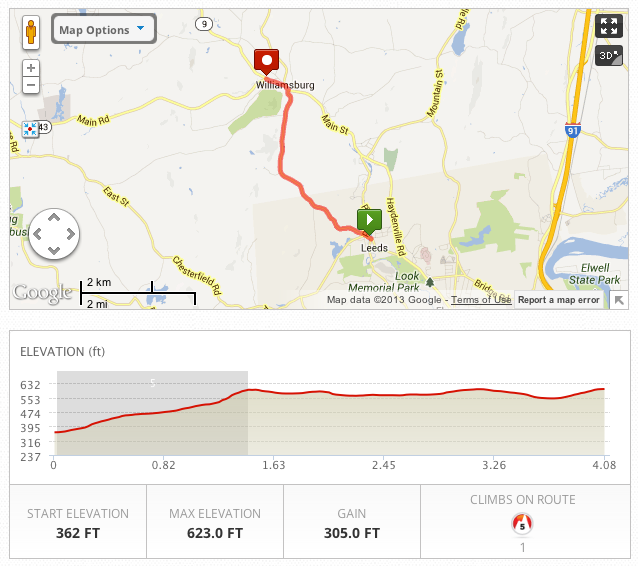
I knew from first-hand experience that traveling northwest on Audubon Road, from Leeds center, was also traveling uphill, vividly depicted here by the elevation chart from MapMyRide:
But the journey up Audubon Road was also a journey back in time. In fact, It was while searching the Internet for information about Leeds, the industrial settlement that grew up along the Mill River in northwest Northampton in the late nineteenth century, that I came across a name from the late eighteenth century that seemed vaguely familiar. Reprinting a 1975 Hampshire Gazette article by Alice Manning, the website of the Leeds Civic Association tells the story of the first settler of the area, Calvin Clark, a former resident of Northampton.
At the age of 22, the year of his marriage, old records tell us that Calvin came into property owned by his father. Histories also tell us that in 1792 Calvin settled “about six miles west from the center of Northampton. The house was built on the farthest direction toward Williamsburg” on what is now known as Audubon Road.
Calvin Clark? Could that be the “C Clark” whose house appears near the Audubon-Kennedy crossroads in John Hales’ 1831 map of Northampton? Was his house still standing? Had I walked and ridden past it on my way to Williamsburg?
I did more research. John H. Lockwood’s Western Massachusetts: A History, 1636-1925 told me more about Calvin Clark, his son Justin, grandson Edward, and great-grandson Charles Edward, all of whom lived on the farm in northwest Northampton, on what is now Audubon Road.
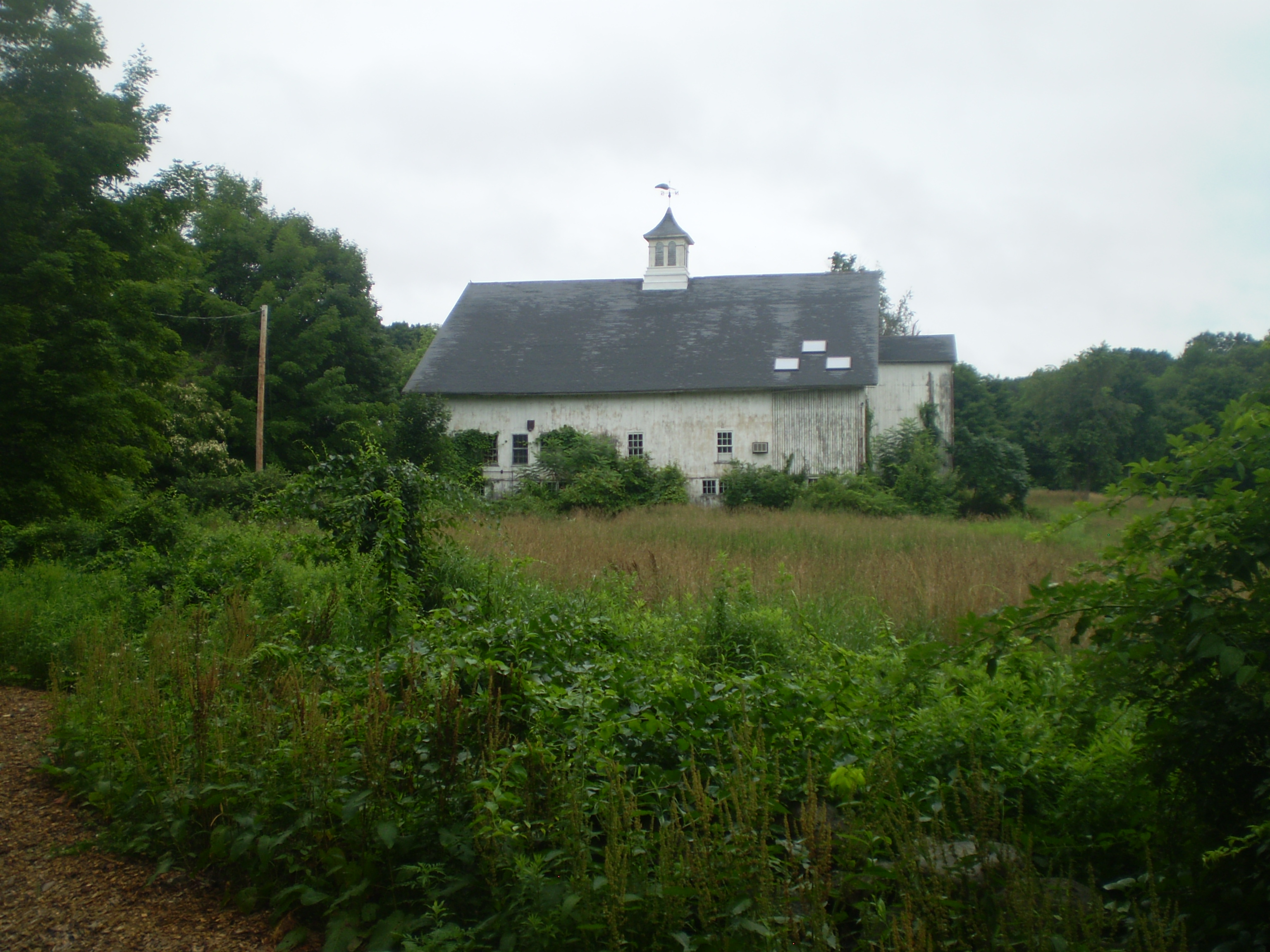
Of Charles Edward Clark, Lockwood writes that he was born in Northampton in 1857 and educated in area schools. “He has always lived on the farm settled by his great-grandfather, the place where his father and grandfather were born. He owns some three hundred acres of land, keeps a fine herd of pure bred Holstein cattle, and does an extensive dairying business in the sale of milk.” An 1896 biography, meanwhile, reports that those cows were kept in a well-equipped barn, built in 1882, and that “the house in which [Clark] resides was erected by his father over forty years ago, and the boards in the dining-room floor have been in use over one hundred years, having done service in the floor of the east room in the old house of the great-grandfather.” Clark’s only son died in infancy; a surviving daughter spent her adulthood elsewhere. My guess is that the farm passed out of the Clark family in the early twentieth century.
But I believe the homestead still exists, fully intact, near Leeds in northwest Northampton. If you bike, walk, or drive up Audubon Road today, right before the intersection with Kennedy Road and the border with Williamsburg, you’ll see on the right, at the exact place where “C Clark” is written on the 1831 John Hales map, a beautiful old farm. Here’s the barn, which I believe to be the one constructed in 1882 by Charles Edward Clark and described above:
And here’s the house itself, set back a little from the road, but still, more than a century and a half later, a stately and distinguished rural domicile:

Here’s the view from a slightly different angle:

In Google’s satellite view, you can see the house, and especially the barn, right above the words “Audubon Rd,” just before the artery curves south. I believe this is the same homestead marked “C Clark” in the 1831 John Hales map of Northampton:
If my recent post on “The Way to Williamsburg” was mainly a trip through the old mill towns of late nineteenth century industrial Northampton, this post on Audubon Road has been a journey further back in time, to the pre-industrial eighteenth and nineteenth century, when widely-separated family farms dotted the hills above Northampton.
My curiosity somewhat satisfied regarding Audubon Road, I find myself now wondering about the old cemetery I passed while riding south on West Farms Road toward Easthampton . . .
For the article on Calvin Clark, click here.
For the articles on Charles Edward Clark, click here and here.
