
The Raleigh, North Carolina, of my childhood and youth was a constantly growing, ceaselessly expanding boom town. Every day, it seemed, some new shopping mall, office complex, or housing development opened; every week, a new road or highway was cut through the landscape; every year, the population swelled, and the town’s borders reached further out into the countryside. The steady destruction of existing environments – and the continual building of new ones – were such constants in our lives that they became unremarkable to us: This was how the world worked.
Years later, when I moved to Pittsburgh – a town then actually losing population – it took me several weeks before I realized the source of the strange calm I felt in that place. There was no construction! no cranes in the sky, urging the city upward; no excavators noisily cutting roads into the woods; no tap tap tap of hammers fixing drywall into place. For city leaders, and unemployed workers, the silence must have been deafening; for me, there was something appealing about being in a world that was – or at least seemed to be – finished, complete, done. I thought I might actually comprehend the place, learn once and for all its shapes and contours, come to inhabit it in a way I never could Raleigh, with its ceaseless change.
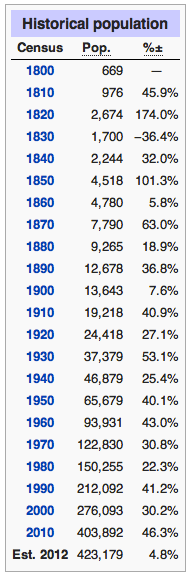
Raleigh’s population. Wikipedia
Of course, I’m sure there was construction going on in Pittsburgh in the early 1990s just as I’m sure the Raleigh of the 1960s and ‘70s experienced periods of flat, or even negative, growth. But statistics suggest that Raleigh really did expand at an unusually fast pace in the second half of the twentieth century. Between 1940 and 2000, according to NCpedia, the town’s population increased eightfold, as it moved from fifth to second largest city in the state. In fact, every decade of the twentieth century showed double-digit increases in Raleigh’s population.
Take the twenty years following World War II: Raleigh’s population during this period doubled, from nearly 54,000 to more than 103,000, as its size tripled, from 12.5 square miles to 34.1 square miles (Little 6-7). Of course, from our vantage point today, the Raleigh of 1965 looks positively quaint: in 2012, the city’s population stood at more than 423,000, and its size, 143 square miles – four times the earlier figures. Such remarkable growth, over such an extended period of time, is not unique in this country, but it is still impressive. It suggests that the postwar boom in Raleigh never really subsided; even today, according to Forbes magazine, Raleigh is the second fastest growing city in the United States.
And yet, for all that, my childhood in Raleigh was far from unsettled. If the town’s population was constantly growing, its borders ever expanding, its center always shifting, the life of my family was, or at least seemed to me to be, extraordinarily stable, situated, rooted. We moved to Raleigh in 1964 when I was three years old; my father had joined a medical practice there. After a year on Pinecrest Drive, off Wake Forest Road, we moved to a part of the city – north of downtown but still inside the beltline – where my parents and two of my siblings live to this day, 50 years later. We resided in three houses in this area, on Wilson Lane from 1965 to 1969, on Transylvania Avenue from 1969 to 1979, and on St. Mary’s Street from 1979 to the present (although by the time my parents moved to this house, my siblings and I had all moved out). The last three houses are all within a mile or so of each other.
It was a good place to raise a family: there were children everywhere and lots of woods and yards to play in. It was far from downtown, but we didn’t think of it therefore as suburban – we thought of it as part of Raleigh. The house on Transylvania Avenue, for example, a large brick colonial revival, was brand new when we moved in in 1969; but the neighborhood itself, called Country Club Hills, had been laid out in the late 1940s, with large wooded lots meant for custom-built houses; there were steep hills and deep ravines, some undeveloped to this day. That, combined with the lush growth of the Southeast – the pine trees and azaleas – gave the place a different look than the suburbs one saw in magazines or on TV, with their tract housing and flat, identical yards.
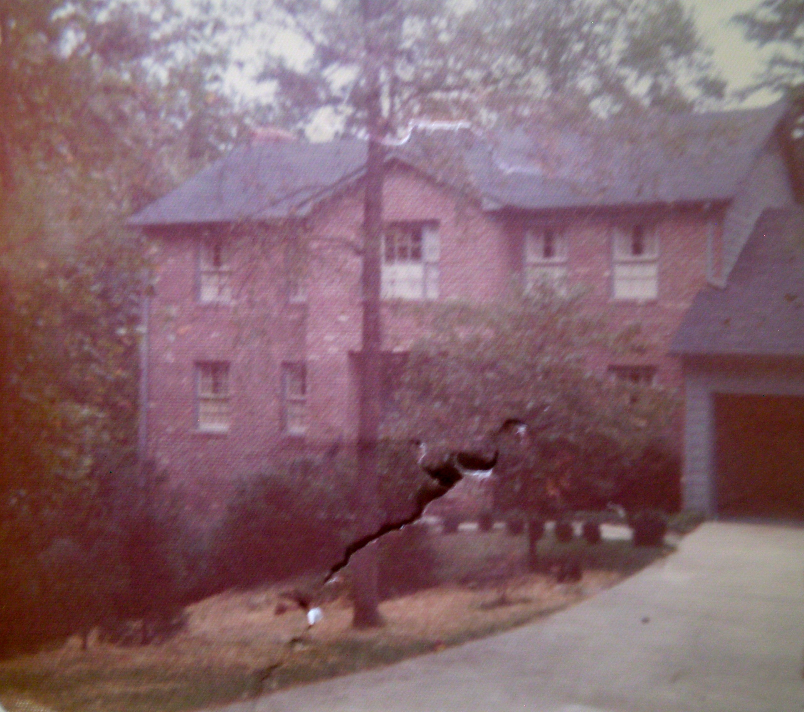
The house on Transylvania Ave., c. 1975
And if the city itself, at that time, was looking outward, beyond the new “beltline” and toward the expanding suburbs of north Raleigh, we tended to look inward, toward the nineteenth century city center downtown and the early twentieth century neighborhoods close by – what people today sometimes call “old Raleigh.” My parents had gone to college in the early 1950s on Hillsborough Street, near downtown. Our church was on Capitol Square. My father’s first medical office was in Cameron Village, a shopping center built after World War II near one of the old streetcar suburbs surrounding downtown. And we all went to high school at Needham Broughton, an imposing 1929 Italian Romanesque structure nearby.
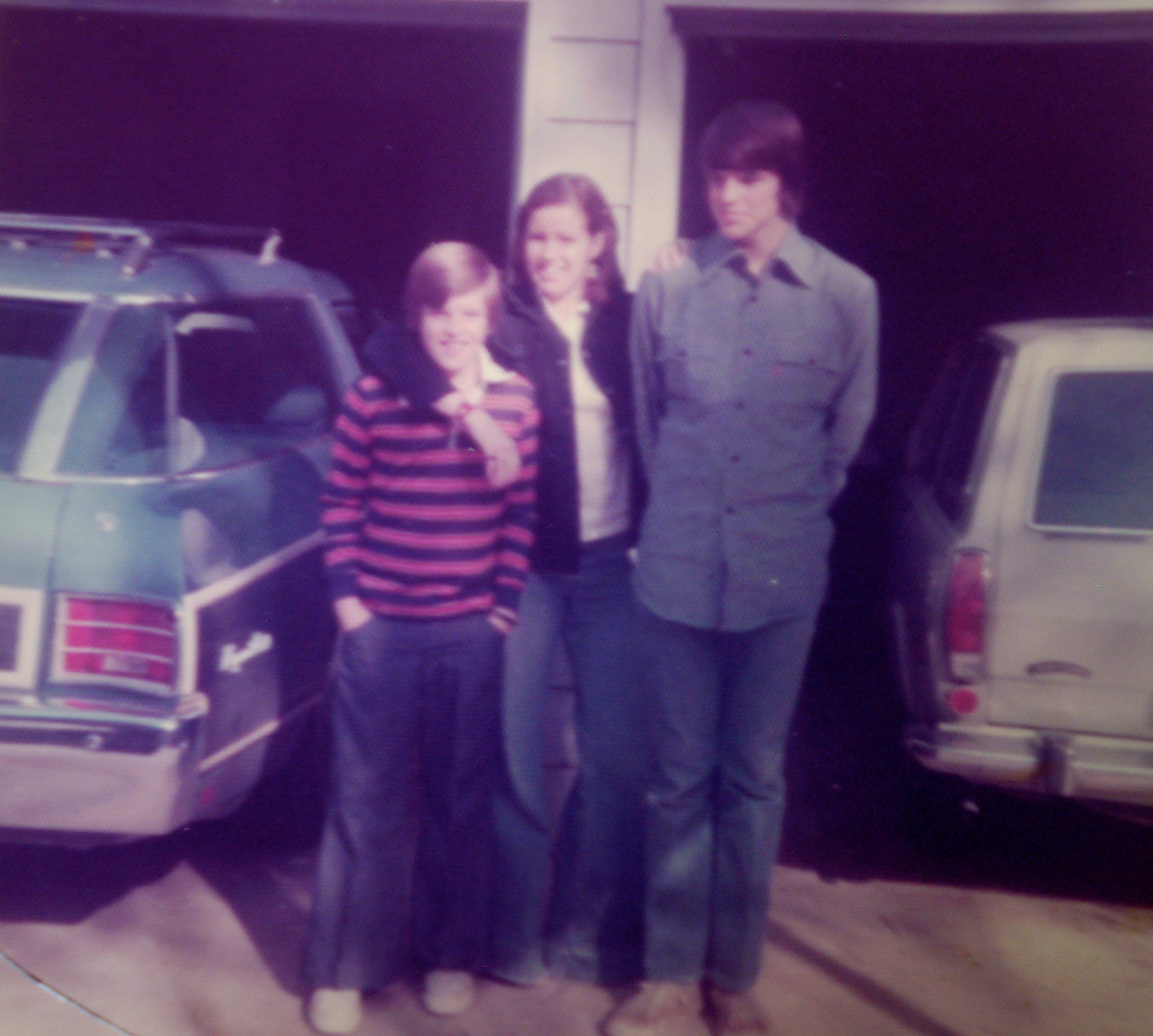
My siblings, c. 1975
But if we thought we were somehow different from, or better than, the “new Raleigh” then emerging beyond the beltline, we were wrong. The fact is, Country Club Hills was, and is, as close to the beltline as you can get without actually being on the other side of it. And we frequently gestured even further out – shopping at North Hills and Crabtree Valley Malls and joining North Ridge Country Club, where we swam in the summer. We might not have thought we were newcomers, but we couldn’t really claim to be “old” Raleigh either; the state capitol was five miles away, after all. Our home on Transylvania Avenue was very much a product of postwar American society and the dramatic social, economic, and cultural changes it wrought: the rise of the automobile, of the consumer, of the teenager – and of white flight. Country Club Hills may have been within Raleigh’s city limits when we moved there in 1969, but just a decade earlier, it had been literally a suburb. And to this day, it exhibits all the defining features of the postwar American suburb.
This connection of one’s own life, however mundane or small, to wider historical developments, to larger sociocultural and political forces, is important to acknowledge every now and then. However hazily one may look back on one’s childhood – that soft enfolding of family and home – one’s life is never one’s life alone. It is always tied to social movements that transcend one’s intimate sphere. None of us is separate from history – even those of us who grew up in nuclear families with detached houses and private automobiles.

The seal of the City of Raleigh. Wikipedia
But it’s not enough to say that my family’s story is inseparable from the wider story of Raleigh’s phenomenal growth in the second half of the twentieth century; it must be acknowledged as well that the growth that benefited my family and eased my way in the world left others, in other parts of the city, in dramatically diminished circumstances, with radically stunted life chances. When we moved into the house on Transylvania Avenue, we didn’t think we were participating in economic inequality or racial segregation or environmental degradation – we were just choosing a house we liked in a place that appealed to us. But no choice of that kind is innocent, and it’s perhaps a good exercise to occasionally remind oneself of that fact and consider what it might mean.
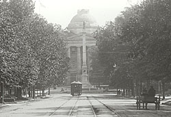
Hillsborough Street, looking east, c. 1900. National Park Service
To tell the story of my family’s life in Raleigh, I want to focus on the development of a streetcar line, on Glenwood Avenue, in the first three decades of the twentieth century. It was a streetcar that first brought people in significant numbers to the northern outskirts of Raleigh and thus prepared the way for my family’s settling on Transylvania Avenue in 1969. It was that movement north, first by streetcar, then by automobile, that enabled Raleigh’s late twentieth century boom. The same movement also contributed to the depression of south Raleigh, which is today much less prosperous than the parts I grew up in.
But I should probably begin the story a little earlier.

Raleigh and Wake County, NC. Wikipedia
Raleigh is one of the few state capitals in the United States that was literally planned as such. Its site, in the middle of Wake County, in the middle of North Carolina, appealed to state legislators in 1788, when they chose their new seat of government because it was less vulnerable to attack than the state’s large coastal cities – Edenton, New Bern, and Wilmington – had been during the Revolutionary War. Here, on 1,000 acres of land purchased from state senator Joel Lane, the new capital city was incorporated in 1792 and laid out in a square grid drawn by another senator, William Christmas.

William Chrismas’ Plan of Raleigh, 1792. Wikipedia
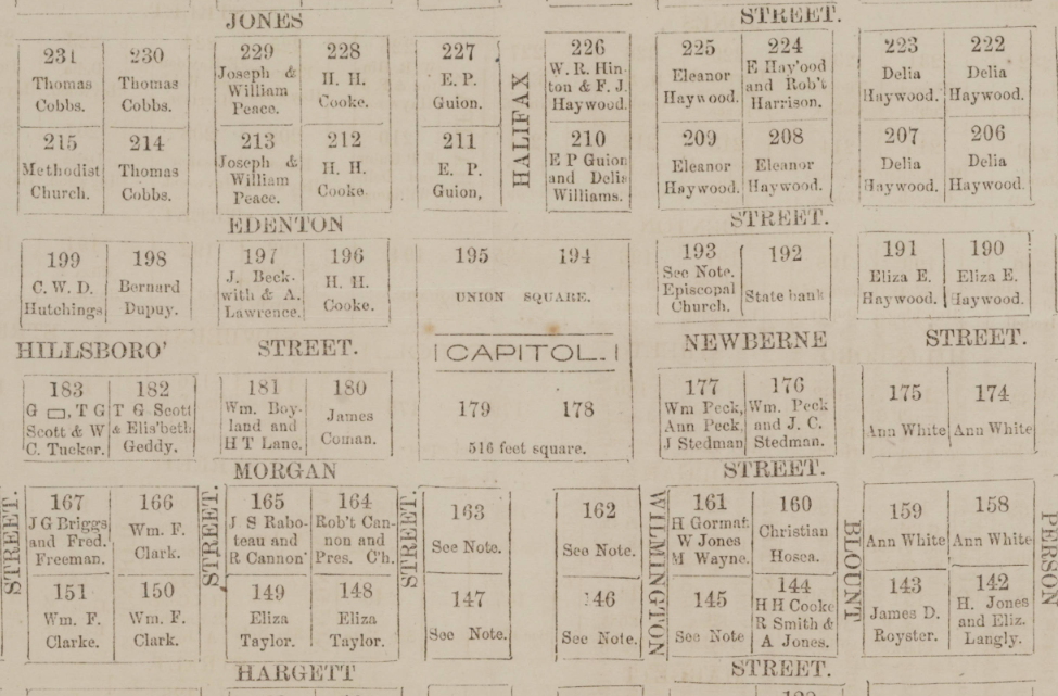
The plan included a Union Square for the state capitol building, with four main streets (Halifax, New Bern, Fayetteville, and Hillsborough Streets) radiating out from it. Four additional squares were planned, and numerous smaller lots were platted. The first city limits were placed along what William Christmas, somewhat unimaginatively, named North, South, East, and West Streets, giving the incorporated town a total area of about two-thirds of a square mile.
Here’s how the town looked, on paper at least, in 1834, with the streets named and most of the lots developed.

1834 Plan of Raleigh. North Carolina Maps
Here’s a detail from the same map, showing the center of town:
1834 Plan of Raleigh (detail). North Carolina Maps
Raleigh grew slowly in the early nineteenth century, a seat of both county and state government but little else. The first physical expansion occurred during a midcentury economic boom when the city’s population doubled, as commercial activity increased and two railroads, the Raleigh & Gaston and the North Carolina, began to connect Raleigh to points east, west, north, and south. It was at this time, in 1857, that the city limits were moved out three blocks in all four directions, retaining the square shape of the original city, and making the city’s size one square mile exactly.
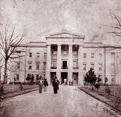
The State Capitol, Raleigh, 1861. Wikipedia
Raleigh was spared major damage during the Civil War, falling in the closing days without a battle. But like much of the South, the city suffered economically during and after the war, only slowly benefitting from the more promising conditions of the late nineteenth century.
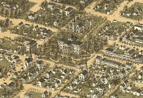
1872 Bird’s Eye View of Raleigh (detail). Wikipedia
The map shown here is a detail from an 1872 “bird’s eye view” of Raleigh, which at that time had about 8,000 inhabitants, more than half of them African-American. You can see the commercial center of the town along Fayetteville Street, to the south (or right) of the capitol. And, at the corner of Edenton and Salisbury Streets, you can see my family’s church, First Baptist, founded in 1812. Diagonally across Capitol Square, on Wilmington Street, you can see another church, also called First Baptist, which was then and remains predominantly African American. The two congregations were originally one; and the respective websites of their churches tell the story of their 1868 separation in subtly different ways.
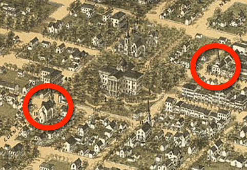
1872 Bird’s Eye View of Raleigh (detail). Wikipedia
Here’s how the white First Baptist Church puts it:
When the Baptist church in Raleigh was organized in 1812 on the second floor of the original state Capitol building, there were 23 charter members—9 white and 14 black. In 1868 there was a peaceful separation of the two groups when the newly emancipated members established their own congregation.
The website of the black First Baptist expands on the story and also tweaks it at certain key points:
First Baptist Church – 101 S. Wilmington Street marks its beginning in the year 1812 when twenty-three persons met in the State House to organize a “Gospel Church” known as the Raleigh Baptist Church. That early Church began with an integrated membership of fourteen (14) slaves of African descent and nine (9) free men presumably of European descent . . . The Church remained an integrated body through the tenure of twelve (12) different white pastors . . . By 1859 the original membership of twenty-three had risen to 228 whites and 208 blacks and the Church had relocated several times to accommodate that growth.
In June of 1868 Henry Jett and a delegation of approximately 200 blacks asked for letters of dismissal from the integrated Church to worship as a separate body under the name of the First Colored Baptist Church. Thus began the era of First Baptist Church as we know it today and the beginning of the tradition of black pastors.”
The late nineteenth century saw other kinds of change besides adjustments to the new racial reality of the post Civil War era. Long a center of county and state government, Raleigh became a center of higher education, too. Two colleges for girls, St. Mary’s and Peace, had been founded before the Civil War; after the war, the first strides toward improved educational opportunities centered on black students. Shaw University, a private liberal arts college and the oldest historically black college or university in the South, was founded by the American Baptist Home Mission Society in 1865; and St. Augustine’s University, which began as a normal school with support from Episcopal clergy, was founded in 1867. Later, the land-grant North Carolina College of Agriculture & Mechanical Arts (today’s North Carolina State University), and the Baptist Female University (today’s Meredith College) were founded, in 1887 and 1891 respectively, on sites along Hillsborough Street to the west of downtown.

In addition to higher education, there was development in other spheres of Raleigh life in the late nineteenth century. In a 1966 article in the North Carolina Historical Review focused on the years 1876-1895, historian Sarah McCulloh Lemmon looked at Raleigh’s development according to four criteria of the “New South,” a term used by progressive white leaders in the late nineteenth century: 1) reconciliation with the north, 2) the quest for industry, 3) the beginning of public education, and 4) urban modernization. For the first criterion, Lemmon quotes from multiple city and state leaders of the time. Her evidence for Raleigh’s industrial growth, meanwhile, focuses on the 1890 opening of the Raleigh Cotton Mill, a key moment in the town’s economic development (the photograph above is from Lemmon 267). Furniture, clothing, ice, paper, and other factories followed suit. (Still, according to the North Carolina History Project, Raleigh never became a manufacturing center like other cities in the state; it did, however, become an important retail hub for eastern North Carolina, a position it still enjoys.)
As far as public education goes, Lemmon recounts the building of Raleigh’s first three public schools: Centennial for boys, Murphey for girls, and Washington for blacks, all built downtown in the 1870s and ’80s, each with eight grades. And she describes the installation of modern public services, such as telephone, water, sewage, sidewalks, gas lighting, electric streetcars, and public parks, in the 1880s and ‘90s. By the turn of the century, according to Lemmon, if Raleigh wasn’t progressing as rapidly toward “New South” status as, say, Birmingham, Alabama, it was making strides. At the very least, it was gaining population, a three-fold increase between 1850 and 1900, from 4,518 to 13,643 inhabitants.

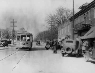
Intersection of Fayetteville and Martin Streets, 1908. Wikipedia
What Lemmon doesn’t mention is the ugly turn that race relations took in Raleigh and across the state at the end of the nineteenth century. In the years right after the Civil War, African Americans in North Carolina, as elsewhere, secured important new civil and economic rights. But once Democrats regained control of the North Carolina legislature in 1870 and the governor’s office in 1876, and once federal troops withdrew from the South in 1877, Reconstruction ended, and African American rights and prospects were gradually curtailed again. This period of white retrenchment lasted nearly twenty years. During that time, rural blacks poured into Raleigh from other parts of the state, searching for a better life; but rural whites migrated here as well. It’s for this reason that Raleigh’s population remained roughly evenly divided between whites and blacks throughout the late nineteenth century. Raleigh’s whites, however, suffering from what one scholar has called “racial claustrophobia,” increasingly felt they were “under siege by displaced black rural refugees” (Mattson 8).
Then, in 1894, a “fusion” party of Republicans and Populists, friendlier to African Americans than the Democrats had been, won both houses of the state legislature; and, in 1896, a Republican governor was elected for the first time in twenty years (and the last time until 1972). Concerted attempts by Democrats from 1898 to 1900 to regain control of state government and prevent further empowerment of the black community included both shocking physical violence and radical constitutional re-engineering. In the 1898 Wilmington Race Riot, “the most serious incident of racial violence in the history of North Carolina” (Encyclopedia of North Carolina, 1208), white Democrats destroyed black owned property, killed and terrorized black residents, and effected a veritable coup d’etat, ousting the biracial fusionist municipal government and installing an all-white Democratic one (at the time, Wilmington’s population, the largest in the state, was nearly two-thirds African American).
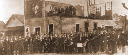
A white mob burns down the office of a black newspaper. 1898 Wilmington Race Riot Commission
Also in 1898, state Democrats regained control of the North Carolina General Assembly and in 1899, building on the “separate-but-equal” doctrine of the U.S. Supreme Court decision in Plessy v. Ferguson, passed Jim Crow laws sanctioning de jure segregation of blacks and whites in the state. They also drafted a constitutional amendment severely limiting African Americans’ right to vote through a mandatory poll tax and literacy test (though a grandfather clause exempted voters who had been registered, or had a lineal ancestor registered, prior to 1867 – that is, most whites). In the general election of 1900, NC voters approved the amendment. From that time until the civil rights reforms of the 1960s, black voter turnout in North Carolina was severely depressed, at times nonexistent (see Encyclopedia of NC, 11, 343-44.)
Importantly, the governor elected in 1900, Democrat Charles Aycock, supported the 1899 constitutional amendment disfranchising black voters. According to the Encyclopedia of North Carolina, Aycock “embodied the two sides of the emerging Democratic agenda” in the state: “[He] was progressive in his desire for markedly better education for white citizens while remaining a steadfast advocate of white supremacy and less-than-equal educational opportunities for African Americans” (335).
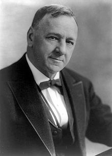
Josephus Daniels, 1862-1948. Wikipedia
Josephus Daniels, the influential owner of the Raleigh News and Observer from 1894 to 1948, Secretary of the Navy during World War I, Ambassador to Mexico in the 1930s, and namesake of my junior high school in Raleigh, has been implicated in both the Wilmington Race Riot and the black disfranchisement project: In 2005, according to Wikipedia, “the 1898 Wilmington Race Riot Commission noted in its draft report that Daniels’ involvement in the overthrow of the elected city government of Wilmington, NC, by actively promoting white supremacy in The News and Observer was so significant that he has been referred to as the ‘precipitator of the riot.’” And, according to the Encyclopedia of North Carolina, Daniels’ paper also played “a leading role in the disfranchisement of blacks in 1900, a ‘reform’ Daniels believed was necessary to remove a corrupt element from state politics and incidentally to ensure the ascendancy of the Democratic Party. Well into the twentieth century the newspaper continued to champion white supremacy and the perpetuation of ‘the white man’s party.’ Although he was later ashamed of the racism that had inspired him in 1898 and 1900, Daniels continued to favor what he considered to be Governor Charles B. Aycock’s approach of solving racial problems through education” (944).
In 1900, then, Raleigh was not only on the cusp of great demographic and economic change, as we saw above; it had also become a center of a newly vigorous white supremacy movement. The two trends: demographic, economic, and physical development, on the one hand, and racial isolation and subjugation, on the other, would become increasingly intertwined in the city’s story moving forward. As Raleigh took off economically in the new century, the benefits of growth were increasingly confined to the white middle and upper classes, who increasingly segregated themselves and their children from the city’s blacks.
We can see this begin to play out in the first decade of the twentieth century. Raleigh’s population grew 41% between 1900 and 1910, from 13,643 to 19,218 inhabitants, its neighborhoods becoming increasingly crowded. Because of this, in 1907, the city limits were pushed out for the first time in 50 years, since the expansion of 1857. Boundaries now extended one mile in each direction from the State Capitol, for a total size of two square miles. The expansion was facilitated by the building of new electric streetcar lines that made travel between downtown and outlying areas easier, and it brought into the city new residential developments then emerging to the north and west of downtown. The three trends – expansion of the city’s physical size, modernization of its intra-urban transportation system, and suburbanization of its (white) middle class – set the stage for Raleigh’s phenomenal growth north and west in the twentieth century and for the isolation and impoverishment of African American residents south of downtown.
Raleigh streetcar. Source: Goodnight Raleigh
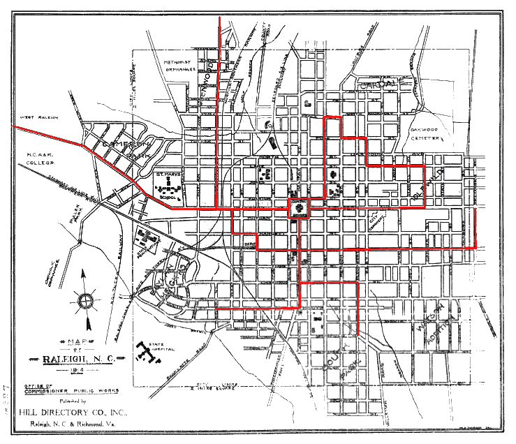
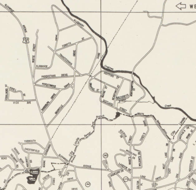
I annotated the map below to indicate the 1792 (red), 1857 (green), and 1907 (black) city limits of Raleigh, shown here inside Raleigh’s present-day beltline (I-440). The blue line running north from downtown is the Glenwood Avenue streetcar line (1906), which terminated in 1912 at Bloomsbury Park – I’ll have more to say about it in a moment.
The biggest physical change to the city in the first decade of the twentieth century was the development of three new suburbs to the southwest, west, and north of downtown. These were Boylan Heights, Cameron Park, and Glenwood. The first, and most important for the future growth of Raleigh, and the one that ultimately led the way to Country Club Hills and my house on Transylvania Avenue, was Glenwood, the neighborhood which “marked the beginning of the suburbanization of land north of Raleigh’s city limits” (Raleigh Historic Development Commission – hereafter, RHDC) and “the first major documented attempt by the city’s controlling interests to accommodate the rapidly growing white middle class of early 20th century Raleigh” (Nomination of the Glenwood-Brooklyn neighborhood to the National Register of Historic Places [hereafter, NRHP], 78).
My annotation of Shaffer’s 1888 Map of Raleigh. North Carolina Maps
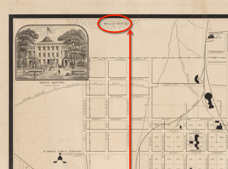
At the time, Glenwood, and a conjoining rural neighborhood, Brooklyn, were on the northwest outskirts of the old downtown, an area once known as Will’s Forest, after a freed slave who lived there in the late 1700s (see red circle above). In the mid-nineteenth century, John Devereux Jr., and his wife Margaret Lane Mordecai had a house, also called Will’s Forest, on the south end of today’s Glenwood Avenue. After the Civil War, their daughter Ellen Devereux and her husband John Hinsdale built a house called Glenwood on the northwest corner of present-day Glenwood Avenue and Peace Street (NRHP, 79). The area was originally reached by Saunders Street, which began within the 1857 limits of the city, extending north from Hillsborough on the west side of downtown (see red line above). By the turn of the twentieth century – its population soaring, its older neighborhoods full, and its white middle class residents looking to distinguish themselves from their perceived inferiors – Raleigh started knocking on the door of this area.
The map below shows the south end of Glenwood Avenue today:
In May, 1905, the Glenwood Land Company was incorporated in Raleigh by James H. Pou, Albert Murray, and William J. Andrews; its purpose was to develop residential properties along the new Glenwood Avenue, which extended the route of the old Saunders Street. “In June 1906 the company registered a plat of the present Glenwood neighborhood, extending from West Peace Street to Wade Avenue. About the same time a streetcar line was extended down Glenwood Avenue, which became the development’s grand concourse. New streets were laid out and given the names of United States presidents (including one contender, the 1876 popular vote winner Samuel J. Tilden)” (NRHP, 80).

Early Twentieth Century Suburbs in North Carolina, Bisher & Early, eds. (Raleigh, 1985), p. 25
The combination of the 1905 incorporation of the Glenwood Land Company, the 1906 construction of the Glenwood Avenue streetcar line by Raleigh Electric (later, Carolina Power & Light, now Progress Energy), and the 1907 extension of the city limits to include the new housing development, was no coincidence. The force behind it all was James H. Pou, a Democrat active in state and local politics, a trial lawyer famous for his courtroom eloquence, the president of the new Glenwood Land Company, and a member of the board of directors (and later chief counsel) of Raleigh Electric, which owned the streetcar line that bisected his real estate development. Pou was clearly adept at using his connections and skills both to transform Raleigh’s landscape and to enrich himself and his partners.
1900 block of Hillsborough St., c. 1928. Goodnight Raleigh
Of course, governmental and corporate interests would not have been furthered if they didn’t tap into the needs of city residents themselves. According to historian Charlotte Brown, there were three main reasons behind the development of Glenwood and similar projects: a need for housing in the rapidly growing capital city of a rapidly urbanizing state, a need for housing specifically for workers in the expanding areas of education, government, and services, and the increasing need of that population for “outward signs of personal and group status.” As Brown and others have shown, Raleigh in the late nineteenth and early twentieth centuries was quickly becoming much more segregated both in terms of race and class (33); the new suburbs on the city’s west and north sides facilitated that segregation.
Class segregation was achieved in Glenwood by ensuring that the price of both land purchase and home construction was high enough to keep poor whites out; as we’ll see, deed restrictions set a minimum value for any new dwelling. In this way, the development not only provided newly-middle-class whites with attractive modern residences in attractive settings; it allowed them to set themselves apart from people just a rung or two below them on the economic ladder. Indeed, city directories show that the neighborhood became home not to upper-class residents but to “government employees, small business owners, salespeople, [and] railroad employees” (RHDC; also NRHP, 82). But if the wealthy, for the time being at least, were still content to live downtown, especially in the upscale Oakwood neighborhood on the city’s northeast side, there is some evidence that a few white collar workers – lawyers, dentists, etc. – were beginning to settle in Glenwood, especially along wide and fashionable Glenwood Avenue itself.

But it was racial segregation that was most vigorously imposed on this new landscape. According to historian Karen Benjamin, at the turn of twentieth century, black and white Raleighites still lived in close proximity to one another, their communities intertwined, and their schools (though segregated) interspersed throughout the compact, centralized city. The new Centennial School for white children, for example, was located in 1876 right next to Shaw University, a black college. Later, in the 1880s, when Raleigh’s elites moved to northeast Raleigh, building large Victorian homes in Oakwood, the new Governor’s Mansion followed, and another white public school, Murphey, for girls, opened nearby. But even here, blacks and whites lived, worked, and were schooled in close proximity – St. Augustine’s University was located right next to white-only Oakwood Cemetery (227).
What the new suburban developments did in the early twentieth century was to create white neighborhoods from scratch, far from the established sociocultural mix of downtown, neighborhoods that explicitly excluded blacks through legally-enforceable means. This was achieved through vigorous use of racially restrictive real estate covenants, in which homeowners agreed not to sell or rent their property to blacks. According to Richard Mattson, it was the first time in post- Civil War Raleigh that “black exclusion from housing was codified by law” (25). Racially restrictive real estate covenants were eventually ruled unenforceable by the U.S. Supreme Court in 1948; but in Raleigh, they were a prominent part of the real estate market up until that time.
The website of the Boylan Heights Neighborhood Association includes an actual set of deed restrictions from 1909, when that neighborhood, along with Glenwood and Cameron Park, was actively under development:
“In a deed dated 5 October 1909, the Greater Raleigh Land Company, a corporation, and JOHN T. PULLEN, trustee, sold to MRS. GEORGE A. OLDHAM, of Wake County, for $1,455, ‘a parcel of land lying within the corporate limits of Raleigh, being Lots 69, 113, and 114 as described in Book of Maps 1885, p. 114.’ The deed contained the following stipulations:
- “That no dwelling house shall be constructed or maintained on premises 69, 113 and 114 of a less value than $2,000 each,”
- “That no building, other than residences, except barns, stables, or outbuildings used for domestic purposes solely, shall be built on said land, unless by written consent given by the Greater Raleigh Land Company,”
- “That no part of any structure built upon the premises be nearer the front line thereof than 20 feet,”
- “That when any dwelling house is built it shall be connected at owner’s expense with the common sewer,”
- “That no pigs or hogs shall be kept upon the premises in any manner whatever,”
- “That the premises shall not be occupied by negroes or persons of mixed or negro blood, that this shall not be construed to prevent the living upon the premises of any negro servant, who is employed for domestic purposes,”
- “All covenants binding upon the party of the second part, except the 6th covenant, shall expire before January 1, 1920.” (Deed Book 238, p. 441)
You can see here how the development company legally excluded poor whites from the new neighborhood by requiring house construction of at least $2,000; it excluded blacks (of any income class) by simply forbidding their occupancy unless they were servants. The final covenant makes clear the supreme importance of that latter exclusion.
Glenwood today. Michael Zirkle Photography, RHDC
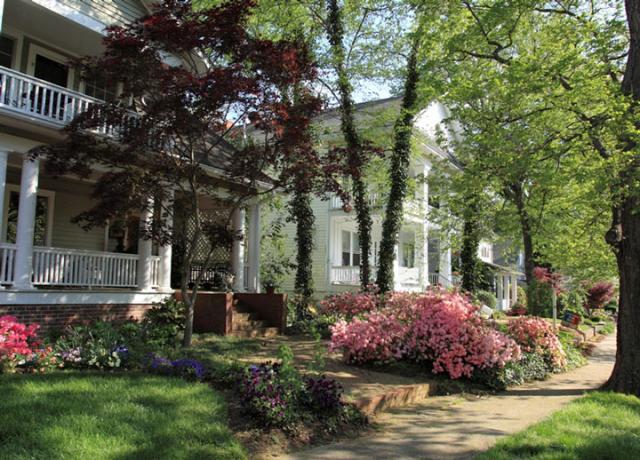
Glenwood was a huge success. In 1907, just a year after it was platted, 100 of the 250 or so lots available (out of an eventual 500 or so) had already sold. By 1908, the Company closed out the development through a lot auction. By then, the neighborhood had established itself as a well-built community, homogeneous in population, and appealingly separate from the disorder, and diversity, of downtown Raleigh, though it was still within a streetcar ride of work, shopping, church, and recreation. And the community was undeniably attractive: neat little houses built in Queen Anne, Colonial Revival, and Craftsman Bungalow styles with front porches and leafy green yards, all set in a compact, walkable neighborhood with easy access to downtown. Like other streetcar suburbs across the country, it has survived into the twenty-first century, intensely desirable again after a dip in the middle of the twentieth century. But when it was built, the place appealed mainly to its residents’ sense of themselves as people rising in the world. According to Charlotte Brown, Glenwood and its sister developments were among the city’s “most vivid images of success and stability” in the early twentieth century, “providing housing for Raleigh’s newly arrived, newly prosperous, newly urban white population” (33).
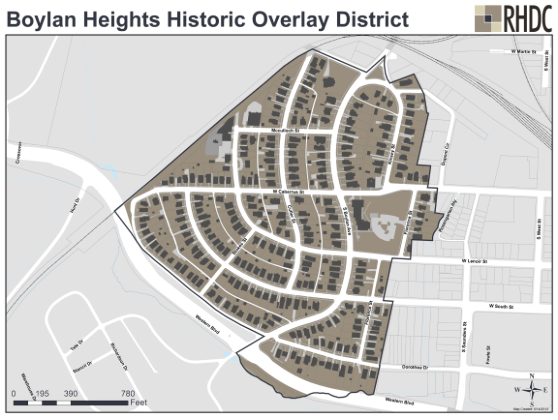
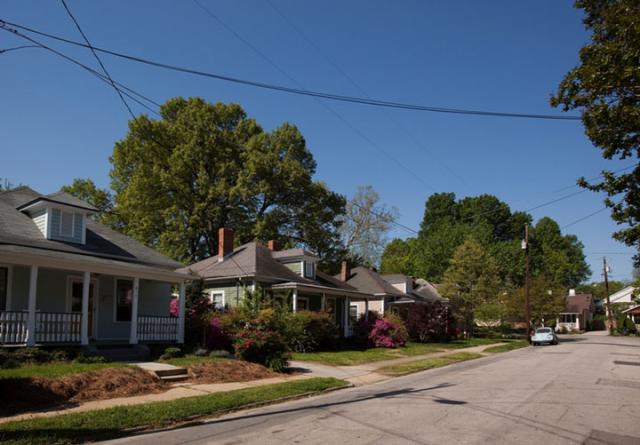
The other new suburban developments of the first decade of the twentieth century – Boylan Heights to the southwest of downtown and Cameron Park to the west – also played a role in Raleigh’s expansion – and its increasing class and racial partitioning. Boylan Heights (1907) is perhaps best known for what was a startling design innovation of the time: winding streets, which “curved aesthetically to match the contours of the hillside site”; it was also designed with a park at its center, later the site of an elementary school (NPS).
Cameron Park today. Michael Zirkle Photography, RHDC. Click here for map of Cameron Park Historic District.
Cameron Park (1910), meanwhile, the last of the big three early Raleigh suburbs to develop, was distinguished from the other two by its more upscale pretensions; the development explicitly targeted upper-middle class residents, including members of Raleigh’s growing professional-managerial class. Like Glenwood, it was sited along a streetcar line, in this case on Hillsborough Street, which took Raleighites out to State and Meredith Colleges, the new State Fairgrounds, and the city’s popular Pullen Park. Like Glenwood, both Boylan Heights and Cameron Park included minimum dwelling costs and racially restrictive covenants in every deed of sale, effectively excluding both poor whites and all blacks from home ownership there.
The map below shows the three suburbs in relation to the 1857 city limits.
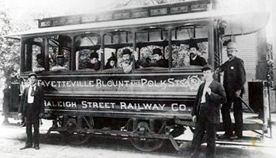
All three neighborhoods are key to the story of Raleigh’s suburbanization. But it was the northern development, along Glenwood Avenue, that figured most importantly in Raleigh’s new century, and it was the CP&L streetcar that accomplished that. It’s not clear how far the streetcar line ran up Glenwood Avenue in 1907, when Pou and his partners were busy selling their lots between Peace Street and Wade Avenue. But by 1912, the streetcar had been extended a full three miles outside of town. It was this streetcar line, and the avenue on which it operated, that lead later investors and residents alike to the Five Points neighborhoods further north on Glenwood; from there, the automobile took Raleigh even further out after World War II, to places like Country Club Hills.
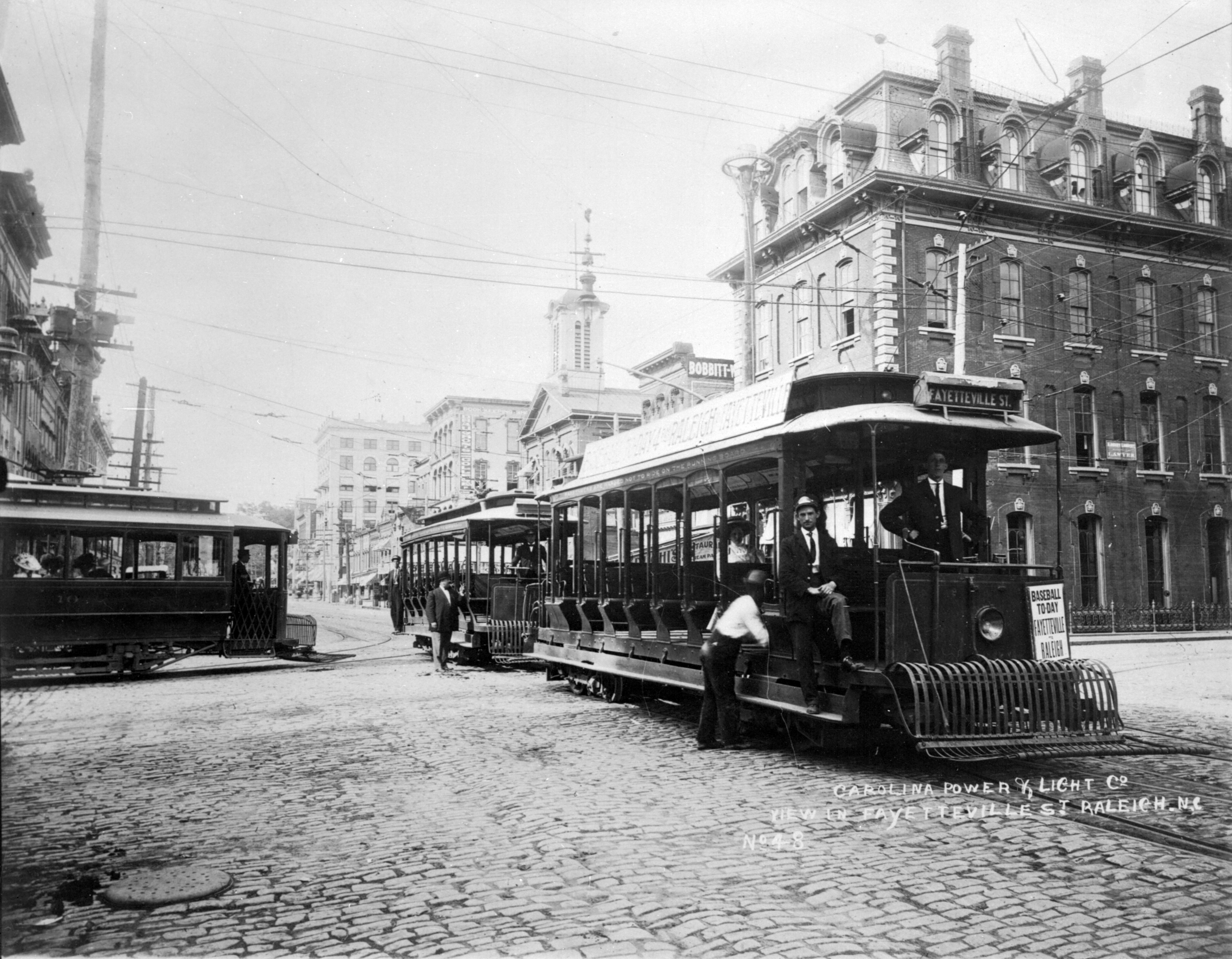
But before we look at those developments, I’d like to look a little more closely at the streetcar itself. According to a 2002 paper by Walter R. Turner, the city’s first streetcar system, operated by the Raleigh Street Railway Company, opened in 1886. It consisted of four miles of track and “four light horsecars” pulled by mules. The transition to electric power took place just five years later, in 1891. The electric system covered the same route as the earlier mule-drawn one: “From downtown, the tracks ran west along Hillsboro Street (now Hillsborough) as far as St. Mary’s College, north on Blount Street to Brookside Park near Oakwood Cemetery, and down Fayetteville and Cabarrus streets to the depot southwest of downtown. When the company failed in 1894, James H. Cutler of Boston . . . acquired more investors and reorganized the company as the Raleigh Electric Company.”
In 1908, Raleigh Electric was absorbed by the new Carolina Power & Light Company, which continued operation of the city’s streetcar system until the early 1930s.
Mike Legeros’ annotation of a 1914 map, showing Raleigh’s streetcar lines. The original map can be found here.
By 1915, according to Turner, the system included twelve miles of track, serving the colleges and fairgrounds on Hillsborough Street west of downtown, running along New Bern Avenue to the east of downtown, and, as we’ve seen, taking passengers three miles out Glenwood Avenue to the north. The length of the Glenwood line by 1912 is remarkable since it went well past any established neighborhoods. Clearly, it was thought that the area along the line would be attractive to future developers and homeowners. In fact, James H. Pou had, by 1905, purchased much of the land on either side of the projected streetcar line well north of his development in Glenwood proper; he was also, in 1910, one of the founders of Carolina Country Club (then called Raleigh Country Club), located at what would soon be the end of the Glenwood line.

Trolley to Bloomsbury Park, 1913. For controversy about this photo, click here.
To get middle-class (white) riders to use that three-mile-long streetcar line to nowhere – and to entice them to look at all the undeveloped land along the tracks – CP&L built in 1912 a 100-acre park, called Bloomsbury, at the Glenwood streetcar’s terminus. At the time, it was not uncommon for streetcar companies to develop amusement parks and other attractions “at the end of the line.” According to Walter Turner, in 1888, the Raleigh Street Railway Company had opened Brookside Park near Oakwood Cemetery, connected to the mule-drawn streetcar system by a spur track. Here, “baseball was a major attraction, along with a merry-go-round and picnicking.” Bloomsbury Park was CP&L’s 1912 answer to Brookside. “Using 8,000 lights, the park was nicknamed the ‘electric park.’ The park’s features included an octagon-shaped pavilion where orchestras played for dances; a Dentzel carousel with a Wurlitzer organ, costing $12,000; a roller coaster; and a penny arcade.”
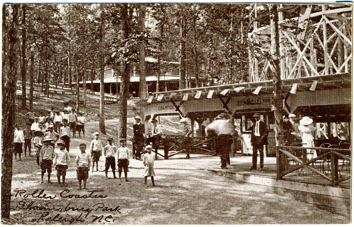
I’ve heard about Bloomsbury my whole life. As a child attending Aldert Root Elementary School in Raleigh, on Lassiter Mill Road, we were told that the amusement park had been on the grounds of our school. There were streets in the neighborhood with the word Bloomsbury in their name. And in the 1970s, friends from my family’s Wilson Lane days formed a band called Bloomsbury Park that played old-fashioned music. But finding reliable, specific information about the park, especially its exact location, has turned out to be surprisingly difficult.


Most historical sources say that the Park was at the end of the Glenwood streetcar line. But about two miles out from downtown, and a full mile from Aldert Root School, today’s Glenwood Avenue bears west towards Crabtree Valley Mall. If the streetcar made it all the way to present-day Root School, it would have traveled the last mile not on Glenwood Avenue, but on today’s St. Mary’s Street, perhaps ending where Lassiter Mill Road begins. But no historical sources mention either of these streets. Other sources say the Park was located where Carolina Country Club is today – but, as we saw above, Carolina Country Club was founded two years before Bloomsbury Park opened, its grounds and golf course already largely coextensive with the property today. It seems unlikely that the Club would have shared grounds with an amusement park. It’s more likely that Bloomsbury Park was located somewhere between Carolina Country Club (founded 1910) and the old Lassiter’s Mill on Crabtree Creek (built 1908), near Aldert Root School today.
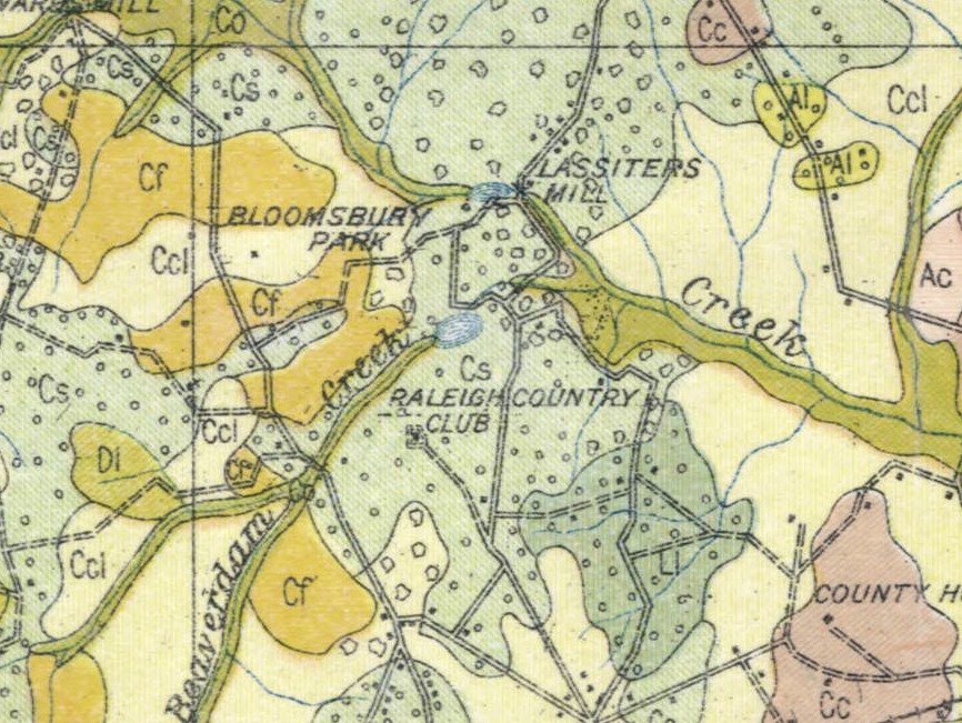
Detail from 1914 Soil Map of Wake County. North Carolina Maps
And in fact, this is where a 1914 soil map of Wake County shows the Park – to the north and west of today’s Root School, between it and Carolina Country Club. Interestingly, a 1928 city map of this area, drawn nearly a decade after the Park closed, shows a very straight Lassiter’s Mill Road (built to carry a streetcar?) branching off from Glenwood Avenue, and, where the street starts to curve a little, a thin black line continues straight to just below Lassiter’s Mill itself. Is this the old streetcar line? If so, it suggests, as does the evidence above, that the 1912 streetcar turned right off Glenwood Avenue, two miles from downtown, then ran up today’s St. Mary’s Street for another mile or so, ending perhaps where that street becomes Lassiter Mill Road, just south of Aldert Root School. The park itself would then have been to the left, in the hilly, wooded part of Country Club Hills between the Carolina Country Club lake and Aldert Root School.
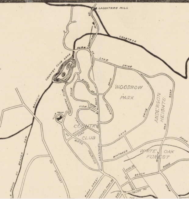
Detail of 1928 map of Raleigh. North Carolina Maps
Here’s a closer view:
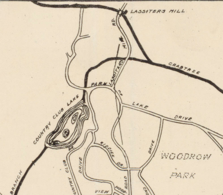
Detail of 1928 map of Raleigh. North Carolina Maps
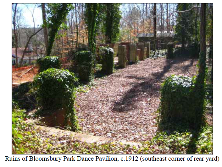
But the best evidence I’ve found for the location of Bloomsbury Park is from the 2008 nomination of the 1953 Bill and Betty Weber House at 606 Transylvania Avenue for Raleigh Historic Landmark status. The document includes striking photographs of the Weber’s back yard, with visible ruins of the Bloomsbury Park Dance Pavilion (the photograph below is from p. 12).
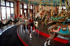
Bloomsbury Park seems to have died as quickly as it began. In 1920, just eight years after it was installed, the famous Dentzel carousel was moved to the city-owned Pullen Park off Hillsborough Street near downtown, where it sits today, listed on the National Register of Historic Places. The rest of Bloomsbury Park seems to have been abandoned, perhaps soon after the end of World War I, most likely for financial reasons.
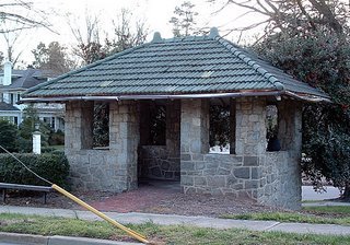
Streetcar shelter at Glenwood Ave. and Harvey St., c. 1918. Source: Goodnight Raleigh
The Glenwood streetcar Line, however, continued to operate for another decade or so, the land alongside it gradually built up all the way out to the country club. Tracks for the old Glenwood line are sometimes still found during road construction – as are tracks from the old Hillsborough Street line. But to me, the most poignant reminder of Raleigh’s streetcar past is the little shelter, shown here, at Glenwood Avenue and Harvey Street. According to the Hayes-Barton NRHP nomination (Section 7, Page 38), it can be dated to “c. 1918.” This would place its construction more than 10 years after the opening of the Glenwood neighborhood to the south but just a couple of years before the start of “the second wave of white suburban development” in Raleigh to the north (RHDC).
As Raleigh emerged from the end of World War I, its population continued to surge. The number of inhabitants increased a staggering 53% during the 1920s, almost double the already healthy population growth of the 1910s. In fact, throughout the South, whites and blacks alike were leaving rural areas and moving to the cities in unprecedented numbers, bringing the region at the end of the decade in line with the nation as a whole in terms of urbanization (Benjamin). Raleigh was no exception to this pattern. The problem was that, by 1920, the first suburbs to the west and north of downtown – Boylan Heights, Cameron Park, and Glenwood – were now full, so white middle and upper class residents began looking for housing even further out from downtown, using the Glenwood streetcar line and, increasingly, private automobiles, to scout out the possibilities.
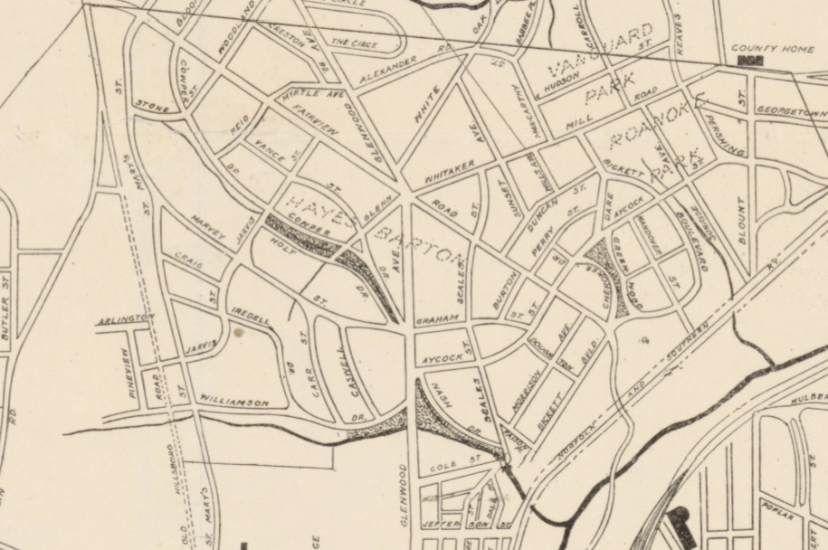
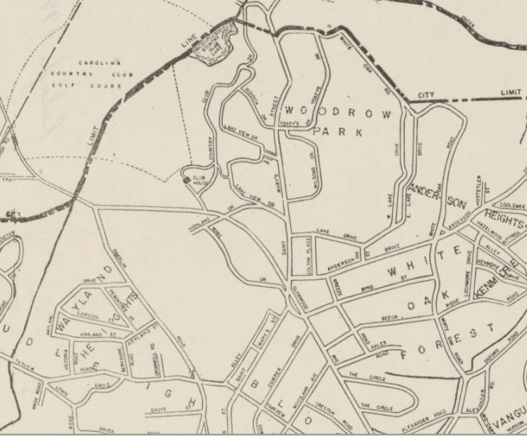
This second wave of suburbanization was centered in the vicinity of today’s Five Points, where Glenwood Avenue, making a slight turn to the northwest, intersects with Whitaker Mill and Fairview Roads (see red pin above). Five historic neighborhoods developed here, mostly in the 1920s: Bloomsbury (platted in 1914 but developed mostly in the 1920s), Vanguard Park (platted in 1915 but only fully built after 1935), Georgetown (platted before 1920 but developed mostly after World War II), Hayes Barton (platted in 1920 and developed rapidly soon after), and Roanoke Park (platted in 1922 and also developed rapidly in the 1920s) (RHDC). All five neighborhoods were sited close to the Glenwood Avenue streetcar line (in fact, James H. Pou had a hand in three of them – Bloomsbury, Georgetown, and Roanoke Park), but the post World War I wave of suburbanization in Raleigh occurred during a transitional period for intra-urban transit in this county; by the mid- to late 1920s, in fact, the automobile was beginning to supplant the streetcar as the key means for residents to move around town.
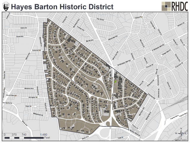
Hayes Barton was the first of the Five Points neighborhoods to fill up – and also the most elite. Designed by landscape architect Earle Sumner Draper, who had designed Charlotte’s upscale Myers Park neighborhood, and platted by North Carolina State College civil engineering professor C. L. Mann, the neighborhood was more like an enclave for the wealthy than a housing development. Residents included newspaper publishers (Josephus Daniels was one of the first to arrive, building Wakestone at 1520 Caswell in 1920) and state supreme court justices. The prevalence of garages in the development, at least in its western section, suggests that the neighborhood was more tied to the automobile than the streetcar – a hint of residential development to come.


Bloomsbury was to the immediate north of Hayes Barton. Also platted by C. L. Mann, it was a much more modest development, catering to middle- rather than upper-class residents, with smaller structures on smaller lots. And, unlike those in Hayes Barton, Bloomsbury’s early customers were very interested in the streetcar line, befitting a development tied to James H. Pou: “No lot over three minutes walk from the car line” touted advertisements for Bloomsbury.
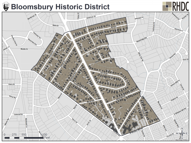
Bloomsbury’s residents were a diverse cross-section of Raleigh’s white middle class. According to the NRHP nomination for Bloomsbury: “The inhabitants of The Circle (formerly Bloomsbury Circle) were especially diverse in 1925. Living side-by-side was a life insurance agent, an attorney, a flagman, part-owner of a roofing company, and a meat cutter. Likewise, Creston Street was inhabited in 1930 by an optometrist, a meat cutter, a physician, two engineers, a division freight manager, and the industrial agent for CP&L.”
Bloomsbury today. Michael Zirkle Photography, RHDC
The description continues: “While the houses located on Glenwood Avenue could not be termed “grand,” they do tend to be some of the larger houses in the Bloomsbury Historic District. Yet, in 1925, the street was home to a relatively diverse group including an auditor, a yard master, a bookkeeper, a pharmacist, a state bridge engineer, an attorney, an insurance agent, and a postal clerk. Overall, Bloomsbury was a middle and upper-middle class neighborhood during its early years with a wide range of occupations represented. The Circle and Crescent Street appear to have been the most diverse in terms of income levels, while streets such as White Oak Road were patently middle class with inhabitants such as a bank cashier, a traveling salesman, a concrete contractor, and the owner of Rand Grocery Company.” (NRHP, Section 8, page 4)
But whether developments targeted the lower or the upper middle class, all the Five Points neighborhoods excluded poor whites and all blacks by deed, using minimal dwelling costs and racially restrictive covenants. By the late 1920s, “white” middle-class Raleigh was even beginning to fret over undesirable elements within its own ranks, especially considering all the new southern European immigrants to the United States during the previous generation; note, for example, the attempted exclusion in 1927 of Gus Russos, a Greek shoe shine parlor operator, from the Hayes Barton neighborhood (see 2002 NRHP Nomination for Hayes Barton, Section 8, Pages 6-7).
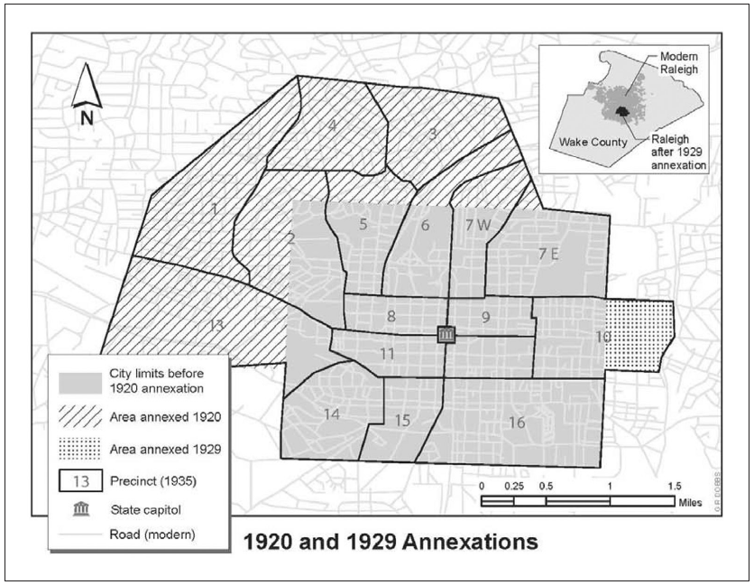
To incorporate the second wave of suburbs, Raleigh’s limits were expanded again in 1920, almost doubling the city’s size and now including all of Hayes-Barton and half of the Bloomsbury neighborhood; in fact, annexation was one of the spurs for the housing boom that occurred in the Five Points area in the 1920s. Inclusion of new suburbs within city limits brought much-needed tax revenues to city coffers; in turn, it gave new residents much sought-after modern conveniences, like phone, water, electricity, and sewage service.
Detail of 1928 map of Raleigh. North Carolina Maps
But where the two earlier expansions of Raleigh, in 1857 and 1907, had pushed the square-shaped city out by equal distances in all four directions, the 1920 enlargement was dramatically uneven – all the annexations were on the north and west sides. In 1920, the city did not, for example, incorporate Idlewild and College Park, two middle-class black suburbs that surrounded St. Augustine’s College and St. Agnes Hospital northeast of downtown, even though these suburbs had developed, like Glenwood, well before World War I (Benjamin 230).
Benjamin 238. Map by Rebecca Dobbs. Base map courtesy of North Carolina Collection, UNC Library at Chapel Hill.
In other words, by the 1920s, Raleigh was officially growing only in the direction of the new middle- and upper-class white areas northwest of downtown, neighborhoods that excluded blacks through overt and legally enforceable discrimination. The trends begun in the 1900s and 1910s toward racial segregation, largely through private real estate restrictions, would now be abetted in the 1920s by local government decisions regarding land annexation and public school siting. Here’s Benjamin again:
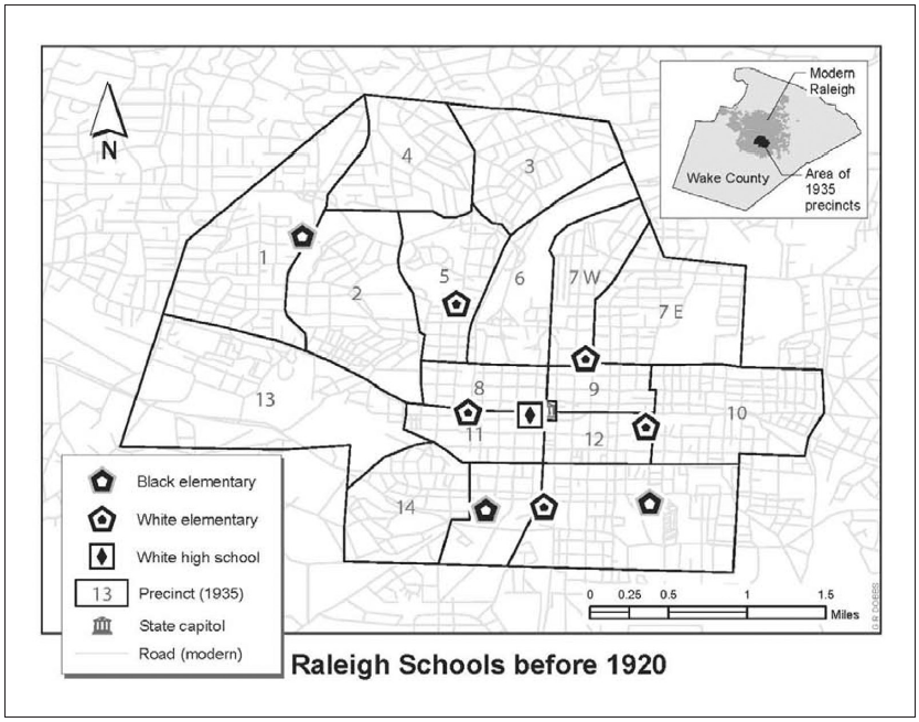
“[I]n 1920, when the city annexed the Five Points suburbs, the layout of the Raleigh schools still reflected a town that viewed Capitol Square as its center. Although residential segregation had increased during the early decades of the twentieth century, black neighborhoods and black schools were not geographically isolated from either white neighborhoods or white schools. Raleigh’s three black schools were Crosby–Garfield in the southeast, Washington in the southwest, and Oberlin in the west. All of them served the elementary grades, since Raleigh had no black public high school. Raleigh’s five white schools were Murphey in the northeast, Thompson in the east, Centennial in the south, Wiley in the west, Lewis in the northwest, and Raleigh High School in the center, just off Capitol Square” (231).
Benjamin 229. Map by Rebecca Dobbs. Base map courtesy of North Carolina Collection, UNC Library at Chapel Hill.
Benjamin continues: “By the end of the 1920s, however, Raleigh’s geographic distribution of schools would more clearly predict the racial residential segregation that marked the post-1945 period. Black schools were increasingly isolated in the southeastern section of the city, and the district’s white schools helped lead the way to the suburbs in the northwest” (231).
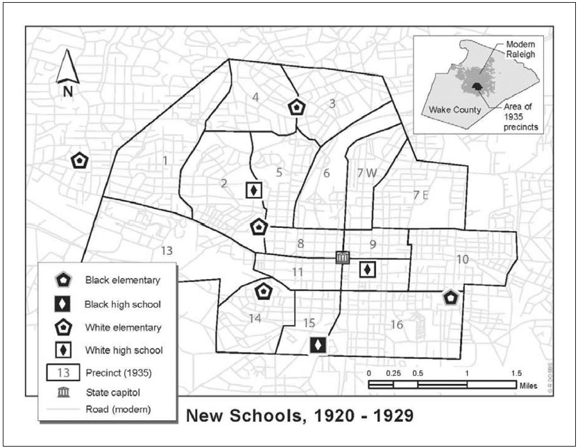
Benjamin 230. Map by Rebecca Dobbs. Base map courtesy of North Carolina Collection, UNC Library at Chapel Hill.
Raleigh’s leaders were thus actively furthering the racial segregation of their town, using annexation and the provision of public services, including education, to support the growth of white only neighborhoods and leaving black parts of town increasingly underserved. Certainly, schools need to follow, to some extent, population growth. But, as Benjamin notes, Raleigh’s school building program in the first half of the twentieth century “acted as a catalyst for white suburbanization and a drag on black suburbanization. Urban developers had enough clout to get their property annexed to the city, extend utilities and streetcar lines into the area, and successfully petition for new schools out of the multimillion-dollar bond issue. In 1926, the Raleigh school district opened the elite Hayes Barton School before most of the lots in Hayes Barton had been sold. Thus, residents moving to the racially restricted northwest suburbs received new schools that were conveniently located in or near their neighborhoods. At the same time, residents in the older parts of Raleigh found their needs increasingly overlooked by school board members and their allies in the Chamber of Commerce” (232).
For example, during the 1920s, the city refused to build a new school for black children near black middle-class suburbs in the northeast part of town, around St. Augustine’s College and St. Agnes Hospital, instead concentrating black schools in the increasingly isolated south side of town (233). And the school board consistently spent less money on black schools, often building a single large elementary school for multiple dispersed black neighborhoods at the same time that it ensured each white neighborhood its own small elementary school, an impetus for only more movement by whites to these areas of town (236). Raleigh’s blacks came to believe, correctly, therefore, that “Raleigh elites wished to shift the city’s white population westward and northward as part of a tacit policy to increase segregation, leaving African Americans in the southeastern part of town with poor housing, few services, and little political representation.” (236).
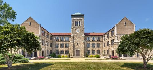
The most controversial decision of the decade was the placement of the new white high school, which opened in 1929 as Needham Broughton, in what was then the far northwest reaches of the city, on St. Mary’s Street, near Raleigh’s new white-only suburbs: Cameron Park, Glenwood, and Hayes Barton. Even many white residents, who still saw Capitol Square as the center of town, protested the siting of the new high school in what was then the outskirts of the city. But the decision had even more impact on the city’s increasingly isolated black neighborhoods to the south and east of downtown. According to Benjamin, “[L]ocal elites chose to locate the city’s premier high school in an area of emerging suburbs that excluded black homeownership through restrictive covenants. As a result, they greatly increased the spatial distance between black and white residents and made future school integration exponentially harder.” (232)
To add insult to injury, in 1931, the Raleigh school board closed white Centennial School in the black south side (236) and in 1955 closed white Morson High School, adjacent to the black business district. “By the time the district faced court-ordered desegregation in 1971, no white schools existed in south or southeast Raleigh and no black schools existed outside of the three census tracts in which African Americans composed at least 95 percent of the population. Likewise, the three census tracts surrounding Broughton High School in the affluent northwest section ranged from 97 to 100 percent white. The only way that significant numbers of black and white students in these census tracts could attend school together was through extensive busing.” (237)
The social problems faced by a severely segregated Raleigh after World War II (continuing in the present), writes Benjamin, were thus a direct result of conscious decisions made by white Raleigh, both in the public and private sphere, earlier in the twentieth century. As resources moved to the north and west of downtown, Raleigh’s blacks were increasingly confined to parts of the city, south and east, that were increasingly isolated from economic growth. According to Richard Mattson, in the 1930s, ‘40s, and later, the black community in Raleigh essentially “consolidated itself into densely populated interior neighborhoods” south of downtown, though it might be more accurate to say that the consolidation was at least partly the work of others (31).
If blacks had never been well treated in Raleigh, their important role in the more compact, centralized, and integrated city of earlier epochs had at least given them some share in the city’s prosperity and even allowed them a thriving middle class community of their own, close by white neighborhoods and the city’s common public resources. As Mattson shows, in the last decade of the nineteenth century, all but two of Raleigh’s 22 barbers were black, and blacks had a virtual monopoly on other businesses of the time, like eating houses (21). The clientele of these establishments included both blacks and whites, and the businesses were dispersed across the square mile city. But in the early decades of the twentieth century, with Jim Crow attitudes on the rise, and white-only suburbs emerging on the northwest outskirts of town, blacks in central Raleigh began to suffer economically. According to Mattson, between 1900-1915, the proportion of black barbershops in the city fell from 82 to 67%; and by 1926, only half of Raleigh’s barbershops were black-owned (23). In other words, when the center of Raleigh, and its resources, began to shift away from Capitol Square, and blacks were neither allowed to participate in that shift nor provided decent public services where they remained, their prospects – and their neighborhoods – rapidly declined.
Of course, the roaring 1920s even for white Raleigh came to a crashing halt in 1929. The 1930s saw continued construction in northwest Raleigh by some wealthy whites and their institutions – the palatial Tatton Hall was built on Oberlin Road in 1935; Rex Hospital moved to St. Mary’s Street in 1937; and the Devereaux Meadow ballpark was built near Glenwood in 1938. But the Depression severely stalled the residential housing market across the city for a decade and a half. Raleigh’s suburban growth wouldn’t take off again until after World War II.
The third wave of Raleigh’s suburbanization, beginning in 1945, was different from the earlier ones in at least two ways. First, it was driven by the private automobile rather than by public transit – Raleigh’s electric streetcar lines, in fact, were all closed by 1933, at least in part because of pressure on public transit systems nationwide by automobile, oil, and tire companies promoting the use of gasoline-powered buses. Second, post World War II suburban development in Raleigh, as elsewhere, was as much about decentralized shopping and office development as it was about home construction. Earlier suburbanites had been content just to reside on the outskirts of the city – they still went downtown for work, shopping, church, etc. After World War II, downtown became every year more and more irrelevant to white Raleigh.
The first sign of this shift remains one of the most impressive. In 1946, Willie York and Raymond Bryan purchased a 160-acre section of the old Duncan Cameron estate adjacent to Cameron Park – one mile northwest of downtown Raleigh and three-quarters of a mile northeast of fast-growing NC State College – and, with the help of designer Seward Mott, began making plans for a large “controlled neighborhood shopping development” modeled on J. C. Nichols’ Country Club Plaza in Kansas City. York believed that a fast-growing, post-war Raleigh was ripe for a mixed-use development of this type (RHDC). Despite initial resistance, the city approved the plan in 1947, and construction began.
Cameron Village housing development today; photo by hmwPreservation, RHDC
In 1949, Cameron Village opened, the first shopping center in the Southeast built away from downtown. By 1950, there were 65 stores on six gridded blocks here. Nearby, York built single-family homes, multi-family apartment buildings, and professional offices, which helped make the shopping center self-sufficient. The residences, mostly Ranch style homes, were all set back from wide curvilinear streets – the first in postwar Raleigh – and had “deep front lawns” (RHDC) with no sidewalks.
Many consider the mixed-use development “the catalyst for the decentralization of retail services in Raleigh” (North Carolina History Project). “Frustrated by the increasing clutter of Fayetteville Street and a lack of downtown parking, shoppers preferred the atmosphere and convenience of Cameron Village.” The project was, and remains, a huge success.
(Just north of the Cameron Village housing subdivision is a three-acre wooded lot, marked above with a red pin, that has no clear owner, no entrance other than an office parking lot, and no one to maintain it other than volunteers, if any. It’s a nearly 150-year-old African-American cemetery that once served the thriving freedmen’s community in Oberlin, then on the outskirts of Raleigh. More information about this nearly forgotten site, recently designated a Raleigh Historic Landmark, can be found in the list of resources at the end of this post, under “Oberlin Cemetery.”)

Oberlin Cemetery. Photo by M. Ruth Little, 2012
Around the same time that Cameron Village opened, in the late 1940s, an exclusively residential neighborhood was laid out on land to the north and west of the Carolina Country Club golf course, way out on Glenwood Avenue but with its southeast corner opening onto St. Mary’s Street/Lassiter Mill Road. According to Ruth Little’s 2006 paper, “The Development of Modernism in Raleigh, 1945-1965,” Country Club Hills was platted in 1946 by NCSU engineer C. L. Mann. It was designed for custom rather than tract housing, its streets named for North Carolina counties, its terrain wooded and hilly, with deep ravines. As we’ve seen, the neighborhood incorporated ruins of the old Bloomsbury amusement park.
When it was first developed, Country Club Hills was outside Raleigh’s city limits. The 1945 map of Raleigh below, drawn right before the neighborhood was platted, shows that the city limits (expanded in 1941) now included parts of Carolina Country Club and most of St. Mary’s Street north of the intersection with Glenwood Avenue. Present-day Lassiter Mill Road was outside the new city limits.
Detail of 1945 map of Raleigh. North Carolina Maps
A 1953 map shows unchanged city limits, but the new neighborhood, Country Club Hills, is now included, albeit outside Raleigh proper.
Detail of 1953 map of Raleigh. North Carolina Maps
Sometime between 1956 and 1959, Raleigh was enlarged again; and, in the 1959 map of the city, Country Club Hills is now within the city limits, though just barely.
Detail of 1959 map of Raleigh. North Carolina Maps
Interestingly, the earliest houses in Country Club Hills, dating from 1949-1954, include a high proportion of modernist structures. In fact, Raleigh has one of the densest concentrations of modernist houses in the country. According to an essay at the National Park Service’s online travel itinerary for Raleigh, the source of the city’s status as a “proving ground for Modernist architecture” was the School of Design at North Carolina State College. “Established in 1948 under the deanship of Henry Kamphoefner (1908-1990), the School of Design quickly became a conduit for new European and South American ideas, as well as those of their chief American proponent, Frank Lloyd Wright, whose influence on North Carolina architecture to that point had been negligible. Dean Kamphoefner recruited several modernist architects as faculty members, and was instrumental in influencing other modernists to come to North Carolina to practice. He also brought internationally-known architects to the school to lecture and to lead studio workshops.”
-
- Kamphoefner House
-
- Fadum House
-
- Paschal House
Kamphoefner’s own house was built in Country Club Hills in 1949, just as the neighborhood opened; it’s at 3060 Granville, right on the golf course. Other notable modernist houses in the neighborhood, some listed on the National Register of Historic Places, and most built in the early 1950s, include the Fadum House at 3056 Granville, the Paschal House at 3334 Alamance, the Albright House at 3078 Granville, the Weber House at 606 Transylvania (that’s the one with the ruins of the Bloomsbury Park dance pavilion in the back yard), the Drew House at 511 Transylvania, the Aretakis House at 309 Transylvania, and the Smith House at 122 Perquimmans (Little).
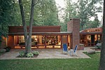
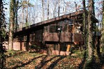
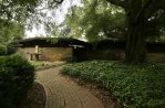
I have especially fond memories of the Paschal house, which architect Frank Harmon has called “the greatest modern house in North Carolina.” We played countless games of basketball on the Paschals’ half-sized court and football in their huge side yard. Unfortunately, in 2013, the 1950 house, valued at more than $3 million, was demolished after it went unsold for more than five years; it’s likely that the three-acre lot will be subdivided into multiple parcels. As the News and Observer noted recently, the Paschals themselves, originally from Philadelphia and politically progressive, considered the house a social statement in their conservative new hometown.
Also modernist in design were the two schools I attended before Broughton: Aldert Root Elementary (built 1958), off of Lassiter Mill Road, and Josephus Daniels Junior High (built 1952) on Oberlin Road. Even the Carolina Country Club had a modernist clubhouse from 1949-1992. A 2013 post at the “Goodnight Raleigh” website includes a photographic timeline of the club’s main buildings, shown below. Note that the current clubhouse, on the right, is meant to have the appearance of an “Old Southern Home,” according to the Club’s own website. Maybe it’s knowing that the Club just accepted, a hundred years after opening, its first African-American members, but I find the structure vaguely offensive. “Old Southern Home”?


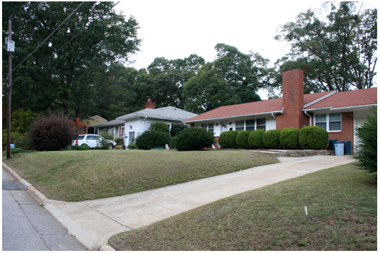
Regarding the modernist houses in Country Club Hills, it should be acknowledged, first, that Raleigh probably never fully welcomed these “progressive” buildings and, second, that the structures were soon outnumbered in the neighborhood by ranch and Colonial style structures. The latter style of house is the kind we moved to in 1969. We had lived the previous four years on Wilson Lane, off of St. Mary’s Street, in a ranch-style house built in 1958. Our new house on Transylvania, just a mile away, was built in 1969, when I started third grade.
The house was big – my brothers and I had our own bedrooms after years of bunking up together; there were porches and decks on the back side, and a large basement where we watched a lot of television. But my most vivid memories of living in Country Club Hills are of the outdoors. I’ve mentioned the Paschals’ basketball court and football field. And I’ve already described the neighborhood’s hilly terrain, which made for adventurous bike riding. There was also, of course, the golf course, which we regarded as just another big yard designed for our amusement. On top of all that, whole acres of the neighborhood, then undeveloped, were like virgin forest to us – including much of the land along Crabtree Creek.
Lassiter Mill Bridge 1975
As for the families, they were intricately linked, not only through us children but through PTA, church, country club, professional, and civic relationships. And everyone, of course, was white. By the 1950s and ’60s, in north Raleigh at least, you didn’t need racially restrictive real estate covenants anymore. We were so far from the black neighborhoods in south Raleigh that we might as well have lived in separate cities.
In a 2013 article in the News and Observer about Carolina Country Club’s first African American members, Frank Daniels, Jr., a club member for more than 50 years, former publisher of the N & O, and grandson of Josephus Daniels himself, said that “The black people I’ve talked to just didn’t want to belong, because they didn’t want to be part of an institution where they would be the only people of color . . . I don’t think it’s a matter of prejudice,” Daniels said. “I just think it’s a matter of not knowing anybody.”
There were black children at my elementary school, though, after 1971, when I was in the fifth grade at Root. That’s when court-ordered busing started in Raleigh as a way to desegregate the public schools. I went to racially mixed public schools for the rest of my time in Raleigh, though there was “academic” tracking in the classrooms and intense social segregation in the cafeteria.
Perhaps it’s no coincidence that, as black children were being bused from south Raleigh to formerly all-white schools in the city’s northwest neighborhoods, the city itself was in the midst of yet another wave of expansion to the north and west. The Research Triangle Park had opened between Raleigh, Durham, and Chapel Hill in 1959; the Raleigh beltline was built from 1960 to 1965 (at least its northern half, there being no reason, as far as the city was concerned, to have highway access to south Raleigh); and Raleigh’s first indoor malls, North Hills and Crabtree Valley, opened in 1967 and 1972 respectively, both of them on the other side of the beltline.
The growth has never really stopped, at least in the northwest quarter of the city.
Here is a recent map showing average household income in Raleigh by census block group, the darker areas associated with higher median income. You can see here the continued economic disparity between north and south Raleigh.
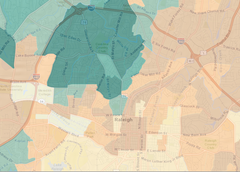
Source: data.raleighnc.gov
Another map using a somewhat different methodology shows much the same socioeconomic landscape.
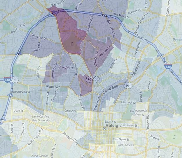
Source: city-data.com
In his 1988 book Ethics After Babel, literary theorist Jeffrey Stout talks about practicing criticism “with both eyes open.” As paraphrased by Kenneth Cmiel in Democratic Eloquence: The Fight Over Popular Speech in Nineteenth Century America, that means “both understanding what is sublime about Don Mattingly’s swing and realizing that professional baseball is big business” (18). It’s easy, or course, to see Don Mattingly’s swing with only one eye open – you derive pleasure from it without bothering to interrogate its sociological ramifications, or you reduce that pleasure to base ideological motivation and refuse to see any inherent value in it whatsoever.
I’ve tried here to look at the Raleigh of my childhood with both eyes open – to acknowledge the extraordinary gifts of that time and place but also to realize that the history that produced that world produced very different outcomes for other people, in other parts of town.
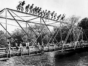
Approaching that story with both eyes open is like acknowledging the thrill of watching a dozen boys, all at the same time, jump off the top of a bridge into a muddy creek, while simultaneously realizing that there’s not a black body among them. It is to wonder how that situation came to be in all its ordinariness, and cruelty, and to pursue that story as carefully, and as candidly, as one can.
I don’t know if I succeeded in that attempt here. And even if I did, I don’t know what that means for moving forward.
UPDATE, July, 2018: See Heather Leah’s “Bloomsbury: Uncovering the remains of Raleigh’s lost theme park,” based, in part on this blog post, at ABC11.com. She located this 1912 map, now in the NC State Archives, that shows definitively where Bloomsbury Park was located.
Karen Benjamin’s article “Suburbanizing Jim Crow: The Impact of School Policy on Residential Segregation in Raleigh” was published in the Journal of Urban History, 38.2 (2012): 225-246.
The two smaller photographs of Bloomsbury Park shown above can be found at this website.
The nomination of the Bloomsbury neighborhood to the National Register of Historic Places (PDF) can be found here.
The Boylan Heights Neighborhood Association can be found here.
Information about Needham Broughton High School, from the Raleigh Historic Development Commission, can be found here.
Charlotte V. Brown’s article “Three Raleigh Suburbs: Glenwood, Boylan Heights, Cameron Park,” was published in Catherine W. Bisher and Lawrence S. Earley, eds., Early Twentieth-Century Suburbs in North Carolina: Essays on History, Architecture, and Planning (Raleigh: North Carolina Department of Cultural Resources, 1985), 31-37. The book is available online here.
Information about Cameron Village can be found at the North Carolina History Project and the Raleigh Historic Development Commission.
Carolina Country Club’s website is available by clicking here; the News and Observer article about its first African-American members can be found here; a relevant blog post at the “Goodnight Raleigh” website by Karl Larson, a.k.a. “Raleigh Boy,” can be found here; and a short article about the club’s 1910 opening can be found in The American Golfer, Dec., 1911, Vol. 7, No. 2: 144-145.
W. Carson Dean’s article “Richard Stanhope Pullen and Raleigh’s First Public Park, 1887-1920” was published in the North Carolina Historical Review, 75.2 (1998): 161-182.
For a recent article about the old Devereux Meadow ballpark, click here.
The Encyclopedia of North Carolina, edited by William S. Powell, was published in Chapel Hill by the University of North Carolina Press in 2006. See also NCpedia.
My book City of Rhetoric: Revitalizing the Public Sphere in Metropolitan America (Albany: SUNY P, 2008) focuses on Chicago and its suburbs, but the story I tell of the twentieth century decentralization, fragmentation, and polarization of the North American sociospatial landscape fits Raleigh as well, to a degree.
Forbes magazine’s article about the fastest-growing cities in the U.S. (2014) can be found here.
Dorothy A. Gay’s article “Crisis of Identity: The Negro Community in Raleigh, 1890-1900” was published in the North Carolina Historical Review, 50.2 (1973): 121-140.
The Historic Glenwood-Brooklyn Neighborhood Association can be found here.
The nomination of the Glenwood-Brooklyn neighborhood to the National Register of Historic Places (PDF) can be found here.
Goodnight Raleigh, launched in 2007, is “an online magazine run by photographers that is updated several times a week with images of the city at night.”
The nomination of the Hayes Barton neighborhood to the National Register of Historic Places (PDF) can be found here.
LEARN NC’s digital textbook on North Carolina history can be found here.
Mike Legeros’ “Hidden Raleigh” website can be found here; “Vanished Raleigh,” with photographs by Elizabeth Reid Murray, is available here.
Sarah McCulloh Lemmon’s article “Raleigh – An Example of the ‘New South’?” was published by the North Carolina Historical Review, 43.3 (1966): 261-285.
M. Ruth Little’s 2006 paper “The Development of Modernism in Raleigh, 1945-1965” (PDF), for the Raleigh Historic Development Commission, can be found here.
Richard Mattson’s 1988 paper “The Evolution of Raleigh’s African-American Neighborhoods in the 19 and 20th Centuries” (PDF), published by the Raleigh Historic Development Commission, can be found here.
Information about modernism in Raleigh can be found in the paper by M. Ruth Little above, a 2012 article in the News and Observer about the George Paschal house, the website North Carolina Modernist Houses, part 5 of the NCpedia article on architecture in North Carolina, at the NPS online travel itinerary for Raleigh, and in the nomination of the Bill and Betty Weber house as a Raleigh Historic Landmark below.
NCpedia is available here.
North Carolina Maps, sponsored by the North Carolina State Archives and University Library at UNC-CH, is available here.
The North Carolina History Project can be found here.
The National Park Service’s online travel itinerary Raleigh: A Capital City, with maps and essays, is available here.
For Oberlin Cemetery, see Ariella Monti’s article in Raleigh Public Record here and M. Ruth Little’s application for Raleigh Historic Landmark designation (PDF) here.
Information about James H. Pou can be found here.
The nomination of the Pullen Park carousel to the National Register of Historic Places (PDF) can be found here.
The Raleigh Historic Development Commission can be found here.
On racially restrictive real estate covenants in NC, click here.
On the controversy about whether or not General Motors killed the U.S. electric streetcar system, click here.
Walter R. Turner’s 2002 paper “The Development of Streetcar Systems in North Carolina” (PDF) for the NC Transportation Museum can be found here.
The nomination of the Bill and Betty Weber House as a Raleigh Historic Landmark (PDF) can be found here.
The website of the 1898 Wilmington Race Riot Commission can be found here.

Hi David,
Your last post was so interesting. I learned a lot of history that I hadn’t heard before. Took me 45 minutes to read it!
Have a great day!
Julie
Sent from my iPad
David, I loved this.
dear david, just finished city of oaks. it is so well written. thank you. it sure does make you think. are you going to make all this into a book. hope you are having a good wkend. dad
Hi David, Your rare commitment, supported by well-researched facts and rendered with impeccable articulation such as you generously share here is a real treat to stumble upon, and I intend on sharing this with a Raleigh-focused Facebook group I manage. I would love to know more about you, and if you offer your services for public venues, as a guest speaker–or other ways in which you keep our earlier, more individual Raleigh alive. Thank you for the important work you put into creating this. I look forward to discovering if opportunities exist to make your acquaintance or hear you speak in the future. Please share any possibilities. Thank you for a refreshing and succinctly informative foray that was certainly worth abandoning my intended hard and fast Saturday morning itinerary for a rewarding and reminiscent read. How touching it was, to come upon your dad’s response, and imagining how his surely stands–eternally dwarfing your work’s assessments from other sources. Best wishes~TCD
Dear David, This is wonderful. Could you be persuaded to flesh out the 1940-50’s timeline with history of Anderson Heights (which comprises Bloomsbury but also the Fallon Park area, which is NOT on the National Historic Registry but should have been put there years ago) and Oxford Woods?
David,
Well worth the time to read – I am sending this to my son who is a senior at Broughton HS – we just moved back to Raleigh 18 months 19 months ago after being away for 32 years. He loves Raleigh and it’s history – and you just gave him a plethora of information. Thank you.
Thank you for your research and thought in this article. We moved to Cameron Park in the early 1960s when my father joined the faculty of the School of Design. My memories of the area are idyllic and innocent. At the same time we were acutely aware of the separation and segregation of people in our beloved city. What “Southside” meant, one side of Oberlin Rd. (an area neglected in this article and I believe the one small pocket of African-American life inside the boundaries of the “new” Raleigh), versus the other side, Halifax Court, the Home, Dix Hill and the other side of Peace St. I don’t know the official designations of all these areas, but as a student at Wiley and later Broughton, there was a wider mix of socio-economic groups and African-American students (pre-force integration) because of the proximity of the areas. Cameron Park was turning over in population from the original owners of houses, to a wave of young professionals, many in the School of Design and also many who were not original to Raleigh, a form of segregation in its own right. My family would never have been accepted at the Carolina Country Club because we did not have the correct family lines. As a child, we just accepted it all as the way it was, but I am glad to know some of the historical context behind the “way it was.”
My grandparents lived at 612 Translvania Ave for many years (1950s through most of my grandmother’s death, she passed in 2007). I think you meant the house at 616 Transylvania is where you can see remains of Bloomsbury Park, not 606. Their home was sold and of course torn down and a new home built. They told us many times over the years that Bloomsbury Park was indeed originally in their back yard. But it was probably before their time- my grandmother was born in 1913! Until this article I imagined that they had gone their themselves, but it sounds like my grandmother would have been a child, so she probably heard about it from others instead… I did see the evidence of the dance floor in their back yard myself, though (612 & 616 Translyvania Ave.)
Nice article, I love learning more about the history of Raleigh!
What a wonderful and informative article about the growth of Raleigh.
Thank you!
Stumbled on this site looking for some other streetcar related stuff for Raleigh. I have one minor tidbit to add regarding Bloomsbury Park. I too took a brief walk around the area looking for rumored ruins and found in the front yard of a house on Scotland St (third house on right from St Mary’s) an obvious concrete slab that is a ruin of a park structure. It is not visible from google street view because it is covered in ivy, but walking down the street it is there and clear to see. If you get a chance check it out.
David, I finally had a chance (long-postponed) to read this thorough and thoughtful article about my home city that Brent Wilson shared on Facebook awhile back. What wonderful research you did! You brought so many Raleigh memories back to the forefront for me.
Although I moved away after high school, I have deep roots in Raleigh. My maternal grandparents lived in Boylan Heights before I was born, and my father, Robert (Paschal) Burns, was a professor in the architecture program at NCSU School of Design as well as being a cousin of the Country Club Hills’ Paschals. When I was young, one of the highlights of my year was going to the Paschals’ annual night-before Thanksgiving buffet in their fascinating modern house, marveling at the sunken fireplace pit, and playing hide and seek with the other children in their back rooms. What a place! I was so sad when it had to be torn down.
Being bussed to south Raleigh to Washington Sixth Grade center, then attending Daniels Jr. High and Broughton Senior High all hold many memories for me. And of course, living in Cameron Park during my angst-filled teenage years (of which you were a part!)
~~ Emily (Burns) Smith
Hi, David! I write a hidden history segment for ABC11 WTVD, and I’d love to set up a time to chat with you about Bloomsbury Park. I’m hoping to do an article about its history, as well as explore the remains of the dance pavilion. My email address is candidslice@gmail.com. If you could reach out, I’d love to schedule an interview! Thanks so much! This was an incredibly detailed historical exploration of Raleigh, and I enjoyed reading it.